ZCZC MIATWOEP ALL
TTAA00 KNHC DDHHMM
Tropical Weather Outlook
NWS National Hurricane Center Miami FL
1100 AM PDT Tue Aug 25 2020
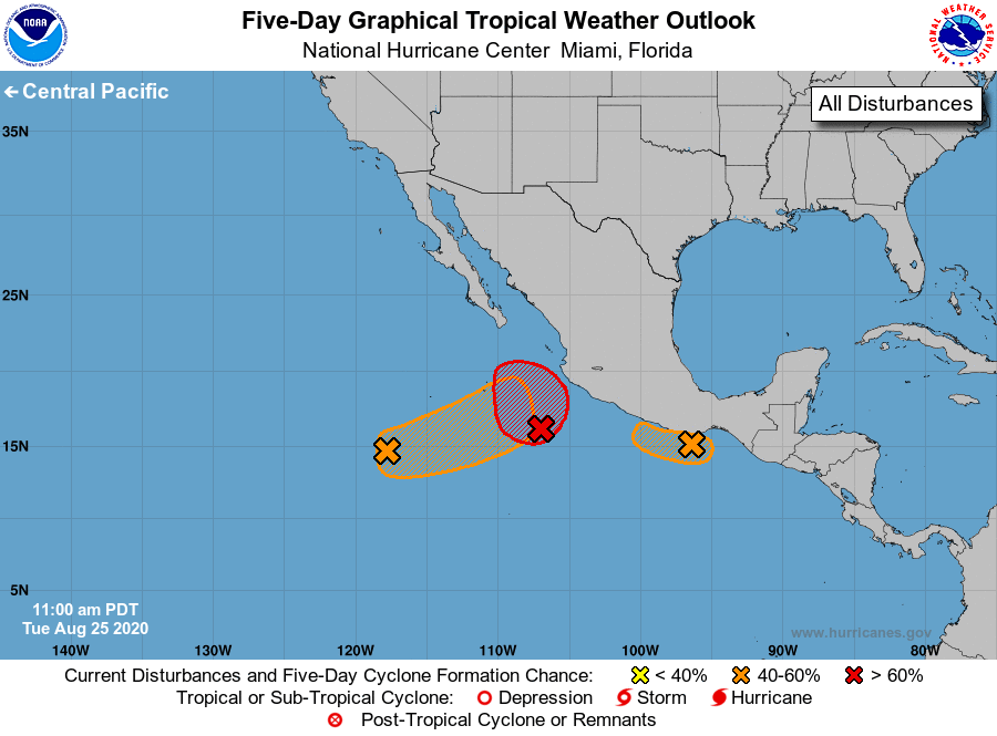
For the eastern North Pacific...east of 140 degrees west longitude:
1. A low pressure system is located a few hundred miles south-southeast
of the southern tip of the Baja California peninsula. Showers and
thunderstorms have become better organized during the past several
hours and the surface circulation has become a little better
defined. Although upper-level winds are marginally conducive for
further development, a tropical depression is likely to form
during the next day or two while the system moves slowly
east-northeastward to northeastward toward the southwestern
coast of Mexico.
* Formation chance through 48 hours...high...80 percent.
* Formation chance through 5 days...high...90 percent.
2. Satellite derived wind data indicate that the small low pressure
system that was located just off of the coast of south-central
Mexico near Puerto Angel has opened up into a trough of low
pressure. Consequently, development of this system appears to be
less likely. Regardless of development, areas of heavy
rainfall and flash flooding are likely in southeastern Mexico and
northern Central America during the next several days.
* Formation chance through 48 hours...medium...40 percent.
* Formation chance through 5 days...medium...40 percent.
3. Another low pressure system is located several hundred miles
southwest of the southern tip of the Baja California peninsula.
Gradual development of this system is possible during the next
couple of days, and a tropical depression could form while it moves
slowly east-northeastward.
* Formation chance through 48 hours...medium...40 percent.
* Formation chance through 5 days...medium...60 percent.
Forecaster Roberts