ZCZC MIATWOEP ALL
TTAA00 KNHC DDHHMM
Tropical Weather Outlook
NWS National Hurricane Center Miami FL
1100 PM PDT Mon Aug 24 2020
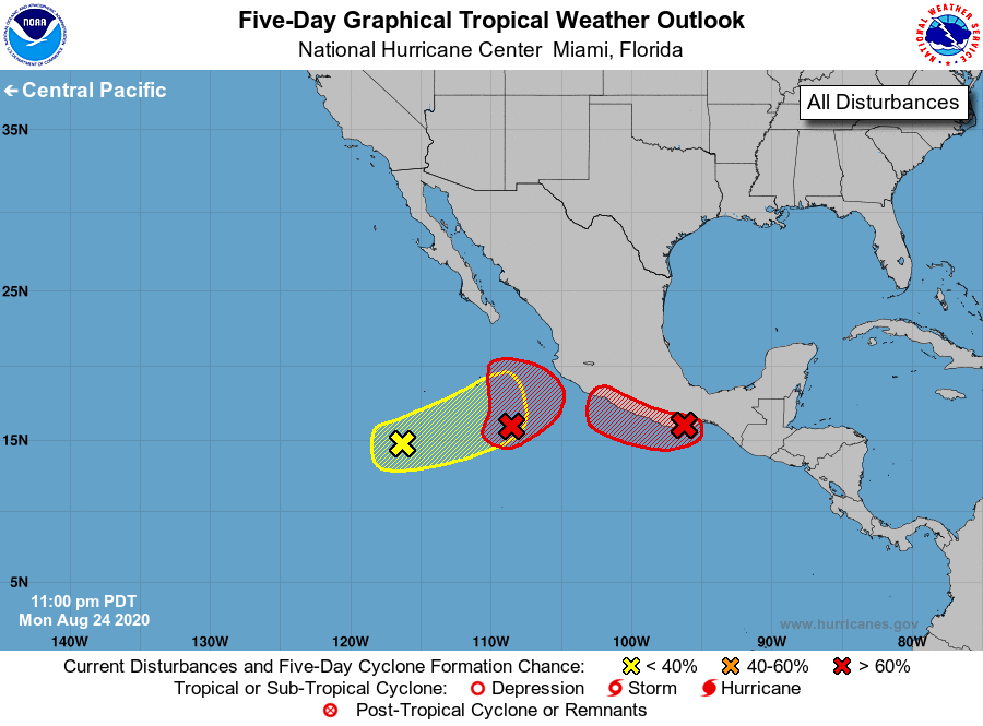
For the eastern North Pacific...east of 140 degrees west longitude:
1. A broad low pressure system is located several hundred miles south
of the southern tip of the Baja California peninsula. Showers and
thunderstorms are beginning to show some signs of organization, and
environmental conditions appear conducive for a tropical depression
to form during the next couple of days while the system moves slowly
east-northeastward to northeastward toward the southwestern coast
of Mexico.
* Formation chance through 48 hours...high...80 percent.
* Formation chance through 5 days...high...90 percent.
2. A small low pressure system has moved inland over south-central
Mexico just north of Puerto Angel. The low is forecast to meander or
move slowly westward to west-northwestward over or near the southern
coast of Mexico, and a tropical depression could still form if the
system moves back out over the water during the next day or two.
Regardless of development, areas of heavy rainfall and flash
flooding are likely in southeastern Mexico and northern Central
America during the next several days.
* Formation chance through 48 hours...high...70 percent.
* Formation chance through 5 days...high...70 percent.
3. Another small low pressure system has developed several hundred
miles southwest of the southern tip of the Baja California
peninsula. Environmental conditions are expected to gradually
become more favorable for development during the next several days
while the system moves slowly east-northeastward.
* Formation chance through 48 hours...low...20 percent.
* Formation chance through 5 days...low...30 percent.
Forecaster Stewart