ZCZC MIATWOEP ALL
TTAA00 KNHC DDHHMM
Tropical Weather Outlook
NWS National Hurricane Center Miami FL
500 AM PDT Sat Aug 15 2020
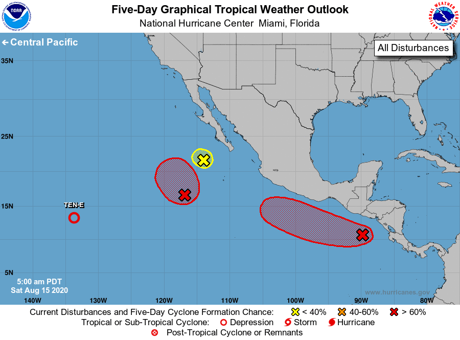
For the eastern North Pacific...east of 140 degrees west longitude:
The National Hurricane Center is issuing advisories on Tropical
Depression Ten-E, located more than 1500 miles west-southwest
of the southern tip of the Baja California peninsula.
1. An area of low pressure located a few hundred miles west of the
southern tip of the Baja California Peninsula is producing a small
area of showers. This system has moved over colder waters and
further development is unlikely.
* Formation chance through 48 hours...low...20 percent.
* Formation chance through 5 days...low...20 percent.
2. Concentrated shower and thunderstorm activity associated with an
area of low pressure is located several hundred miles southwest of
the southern tip of the Baja California peninsula. This system has
slowly become better organized since yesterday and environmental
conditions appear favorable for further development today and
tomorrow. A tropical depression is likely to form while the system
moves slowly north-northwestward or northward during the next
couple of days.
* Formation chance through 48 hours...high...80 percent.
* Formation chance through 5 days...high...80 percent.
3. Showers and thunderstorms associated with a trough of low pressure
located several hundred miles southeast of the Gulf of Tehuantepec
are beginning to show signs of organization. Conditions appear
conducive for further development and a tropical depression or
tropical storm is likely to form later this weekend or early next
week while the system moves generally west-northwestward just
offshore of the southwestern coast of Mexico.
* Formation chance through 48 hours...high...80 percent.
* Formation chance through 5 days...high...90 percent.
Forecaster Zelinsky