ZCZC MIATWOEP ALL
TTAA00 KNHC DDHHMM
Tropical Weather Outlook
NWS National Hurricane Center Miami FL
1100 AM PDT Wed Aug 12 2020
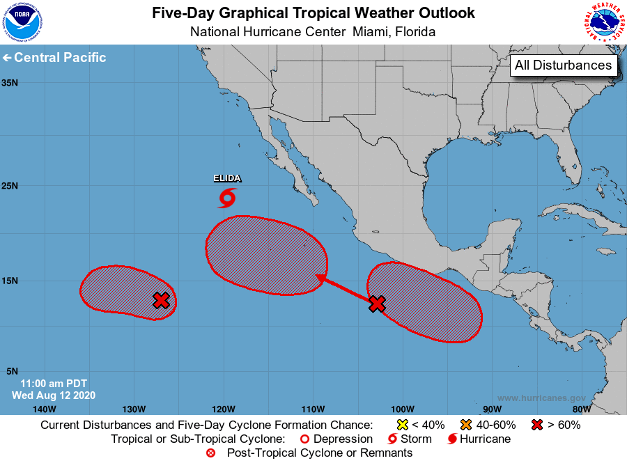
For the eastern North Pacific...east of 140 degrees west longitude:
The National Hurricane Center is issuing advisories on recently
downgraded Tropical Storm Elida, located several hundred miles
southwest of Punta Eugenia, Mexico.
1. Satellite images suggest that a better-defined low pressure area is
forming about 1300 miles southwest of the southern tip of the Baja
California peninsula, and the associated shower and thunderstorm
activity is becoming a little better organized. Environmental
conditions are conducive for additional development, and a tropical
depression is expected to form within the next couple of days while
the system moves slowly west-northwestward.
* Formation chance through 48 hours...high...80 percent.
* Formation chance through 5 days...high...90 percent.
2. A large area of disturbed weather associated with a trough of low
pressure extends several hundred miles southwest of the
southwestern coast of Mexico. Environmental conditions appear
conducive for development, and a tropical depression is
expected to form during the next few days before the system
reaches cooler waters over the weekend. This system is forecast to
move west-northwestward at about 15 mph away from the coast of
southwestern Mexico.
* Formation chance through 48 hours...high...70 percent.
* Formation chance through 5 days...high...90 percent.
3. Another area of low pressure is expected to form in a few days over
the far eastern portion of the basin to the south of the coast of
Central America. Conditions are expected to be conducive for
development, and a tropical depression is likely to form this
weekend or early next week while it moves generally
west-northwestward just offshore the coast of Mexico.
* Formation chance through 48 hours...low...near 0 percent.
* Formation chance through 5 days...high...70 percent.
Forecaster Berg