ZCZC MIATWOEP ALL
TTAA00 KNHC DDHHMM
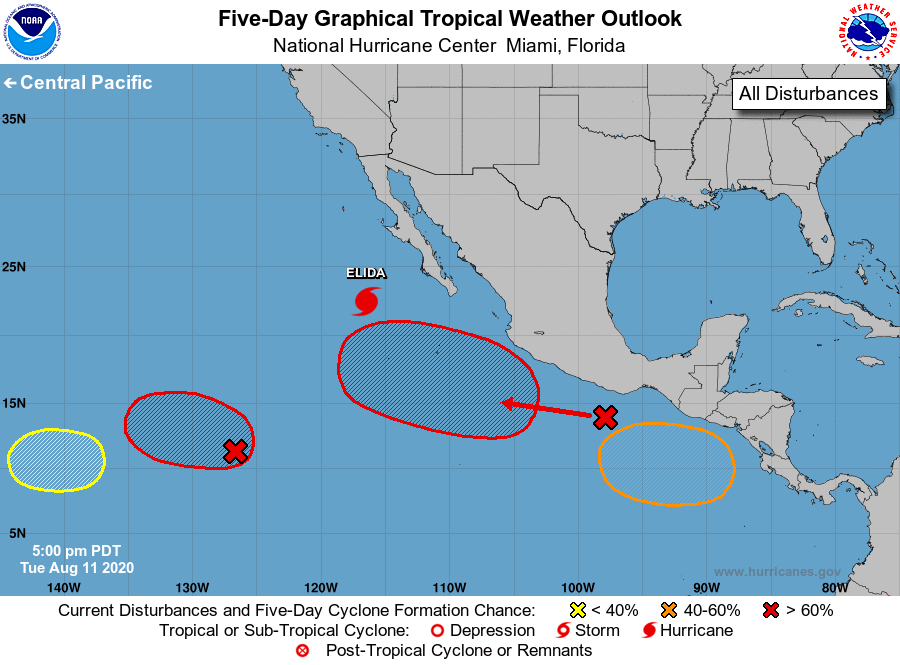
Tropical Weather Outlook
NWS National Hurricane Center Miami FL
500 PM PDT Tue Aug 11 2020
For the eastern North Pacific...east of 140 degrees west longitude:
The National Hurricane Center is issuing advisories on Hurricane
Elida, located a few hundred miles west of the southern tip of the
Baja California peninsula.
1. Recent satellite wind data indicate that the area of low pressure
located about 1300 miles southwest of the southern tip of the Baja
California peninsula remains elongated. The associated shower and
thunderstorm activity is currently disorganized, but environmental
conditions are expected to be conducive for additional development,
and a tropical depression is likely to form within the next few
days. The system is not expected to move as quickly westward as
originally forecast, and a slower westward to west-northwestward
motion is now anticipated over the next several days.
* Formation chance through 48 hours...medium...50 percent.
* Formation chance through 5 days...high...80 percent.
2. A large area of disturbed weather associated with a trough of low
pressure extends from just west of the Gulf of Tehuantepec
southwestward for several hundred miles. Environmental conditions
appear conducive for gradual development over the next several days,
and this system will likely become a tropical depression by late
this week while it moves generally west-northwestward away from the
coast of southwest Mexico.
* Formation chance through 48 hours...medium...40 percent.
* Formation chance through 5 days...high...80 percent.
3. Another area of low pressure is expected to form in a few days over
the far eastern portion of the basin to the south of the coast of
Central America. Conditions are expected to be conducive for
development, and a tropical depression could form this weekend while
it moves generally west-northwestward.
* Formation chance through 48 hours...low...near 0 percent.
* Formation chance through 5 days...medium...60 percent.
4. Another area of disturbed weather is forecast to form over the far
western portion of the eastern Pacific basin within the next couple
of days. Some subsequent gradual development of this system is
possible later this week while the system moves slowly westward
into the central Pacific basin.
* Formation chance through 48 hours...low...near 0 percent.
* Formation chance through 5 days...low...30 percent.
Forecaster Brown