ZCZC MIATWOEP ALL
TTAA00 KNHC DDHHMM
Tropical Weather Outlook
NWS National Hurricane Center Miami FL
1100 AM PDT Tue Aug 11 2020
For the eastern North Pacific...east of 140 degrees west longitude:
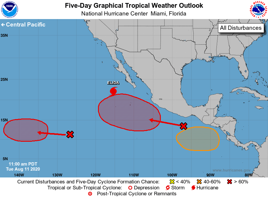
The National Hurricane Center is issuing advisories on Hurricane
Elida, located a few hundred miles west-southwest of the southern
tip of the Baja California peninsula.
1. Satellite imagery indicates that a poorly defined low pressure area
has formed in association with the elongated area of disturbed
weather located around 1300 miles southwest of the southern tip of
the Baja California peninsula. Additional development is expected,
and a tropical depression is likely to form during the next few
days. The system is expected to move slowly westward toward the
central Pacific basin during the next several days.
* Formation chance through 48 hours...medium...40 percent.
* Formation chance through 5 days...high...70 percent.
2. An area of disturbed weather is located a few hundred miles south-
southwest of the Gulf of Tehuantepec. An area of low pressure is
forecast to develop from this system well south or southwest of the
southwestern coast of Mexico in a couple of days. Environmental
conditions appear conducive for development thereafter, and this
system will likely become a tropical depression late this week or
over the weekend while it moves generally west-northwestward.
* Formation chance through 48 hours...low...20 percent.
* Formation chance through 5 days...high...80 percent.
3. Another area of low pressure is expected to form in a few days over
the far eastern portion of the basin to the south of the coast of
Central America. Gradual development of this system is possible, and
a tropical depression could form this weekend while it moves
generally west-northwestward.
* Formation chance through 48 hours...low...near 0 percent.
* Formation chance through 5 days...medium...40 percent.
Forecaster Beven