ZCZC MIATWOEP ALL
TTAA00 KNHC DDHHMM
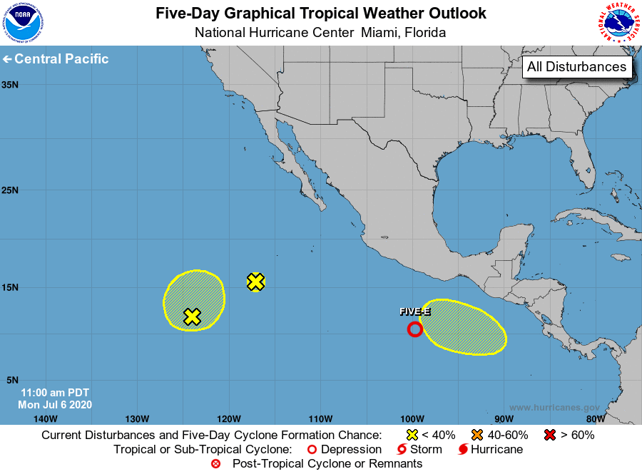
Tropical Weather Outlook
NWS National Hurricane Center Miami FL
1100 AM PDT Mon Jul 6 2020
For the eastern North Pacific...east of 140 degrees west longitude:
1. Shower and thunderstorm activity associated with a broad area of low
pressure located several hundred miles south of Acapulco, Mexico,
have become better organized since yesterday. Environmental
conditions are conducive for additional development, and a
tropical depression is likely to form within the next day or so
while the system moves west-northwestward, well south of the coast
of southern Mexico.
* Formation chance through 48 hours...high...80 percent.
* Formation chance through 5 days...high...90 percent.
2. Showers and thunderstorms associated with an elongated area of low
pressure located several hundred miles southwest of the southern tip
of the Baja California peninsula have become limited. Development
of this system is no longer expected, and it is likely to merge with
another disturbance to its southwest within the next day or two.
* Formation chance through 48 hours...low...near 0 percent.
* Formation chance through 5 days...low...near 0 percent.
3. Disorganized showers and thunderstorms located more than 1000 miles
southwest of the southern tip of the Baja California peninsula are
associated with a broad area of low pressure. Some gradual
development of this system is possible over the next several days
while it moves little.
* Formation chance through 48 hours...low...20 percent.
* Formation chance through 5 days...low...30 percent.
4. Another area of low pressure is forecast to form south of the Gulf
of Tehuantepec late this week. Environmental conditions are
expected to be conducive for subsequent gradual development this
weekend while the system moves westward well south of the coast of
Mexico.
* Formation chance through 48 hours...low...near 0 percent.
* Formation chance through 5 days...low...20 percent.
Forecaster Brown