ZCZC MIATWOEP ALL
TTAA00 KNHC DDHHMM
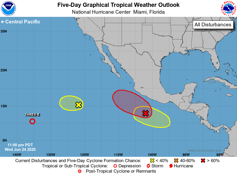
Tropical Weather Outlook
NWS National Hurricane Center Miami FL
1100 PM PDT Wed Jun 24 2020
For the eastern North Pacific...east of 140 degrees west longitude:
The National Hurricane Center is issuing advisories on Tropical
Depression Three-E, located more than 1800 miles west-southwest of
the southern tip of the Baja California peninsula.
1. An elongated area of low pressure located several hundred miles
southwest of the southern tip of the Baja California peninsula is
producing disorganized showers and thunderstorms. Development
of this system is becoming less likely due to unfavorable
environmental conditions.
* Formation chance through 48 hours...low...10 percent.
* Formation chance through 5 days...low...10 percent.
2. Disorganized showers and thunderstorms located a few hundred miles
south of the southwestern coast of Mexico are associated with a
broad area of low pressure. Environmental conditions are forecast
to be conducive for development, and the system is likely to become
a tropical depression within the next couple of days while it moves
west-northwestward parallel to the coast of Mexico.
* Formation chance through 48 hours...high...70 percent.
* Formation chance through 5 days...high...80 percent.
3. Another area of low pressure is forecast to form south of the Gulf
of Tehuantepec by late this week. Gradual development of this system
is possible over the weekend as it moves west-northwestward parallel
to the coast of Mexico.
* Formation chance through 48 hours...low...near 0 percent.
* Formation chance through 5 days...low...30 percent.
Public Advisories on Tropical Depression Three-E are issued under
WMO header WTPZ33 KNHC and under AWIPS header MIATCPEP3.
Forecast/Advisories on Tropical Depression Three-E are issued under
WMO header WTPZ23 KNHC and under AWIPS header MIATCMEP3.
Forecaster Stewart