ZCZC MIATWOEP ALL
TTAA00 KNHC DDHHMM
Tropical Weather Outlook
NWS National Hurricane Center Miami FL
500 AM PDT Fri Sep 27 2019
For the eastern North Pacific...east of 140 degrees west longitude:
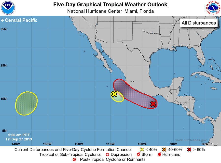
1. A small but well-defined low pressure system located a few hundred
miles southwest of Manzanillo, Mexico, is producing limited shower
activity. Although some slight development of the low is still
possible today, it is expected to become absorbed by a larger
weather disturbance near the coast of Mexico during the next couple
of days, and the chance of tropical cyclone formation appears to be
decreasing.
* Formation chance through 48 hours...low...20 percent.
* Formation chance through 5 days...low...20 percent.
2. A large area of disorganized showers and thunderstorms located near
the southern and southwestern coast of Mexico is associated with an
elongated surface trough. A low pressure system is forecast to
develop along this trough during the next day or two, and it is
likely to become a tropical depression or tropical storm this
weekend or early next week while moving west-northwestward to
northwestward at about 10 mph near the southern and southwestern
coast of Mexico. Regardless of development, heavy rainfall, with
the possibility of flash flooding and mudslides, is expected near
the Pacific coasts of Guatemala and Mexico during the next few days.
* Formation chance through 48 hours...medium...60 percent.
* Formation chance through 5 days...high...80 percent.
3. An area of low pressure is expected to form over the far
southwestern portion of the eastern North Pacific by early next
week. Some gradual development is possible thereafter while the
system drifts slowly eastward or northeastward.
* Formation chance through 48 hours...low...near 0 percent.
* Formation chance through 5 days...low...30 percent.
Forecaster Berg/Hagen