ZCZC MIATWOEP ALL
TTAA00 KNHC DDHHMM
Tropical Weather Outlook
NWS National Hurricane Center Miami FL
1100 PM PDT Thu Sep 26 2019
For the eastern North Pacific...east of 140 degrees west longitude:
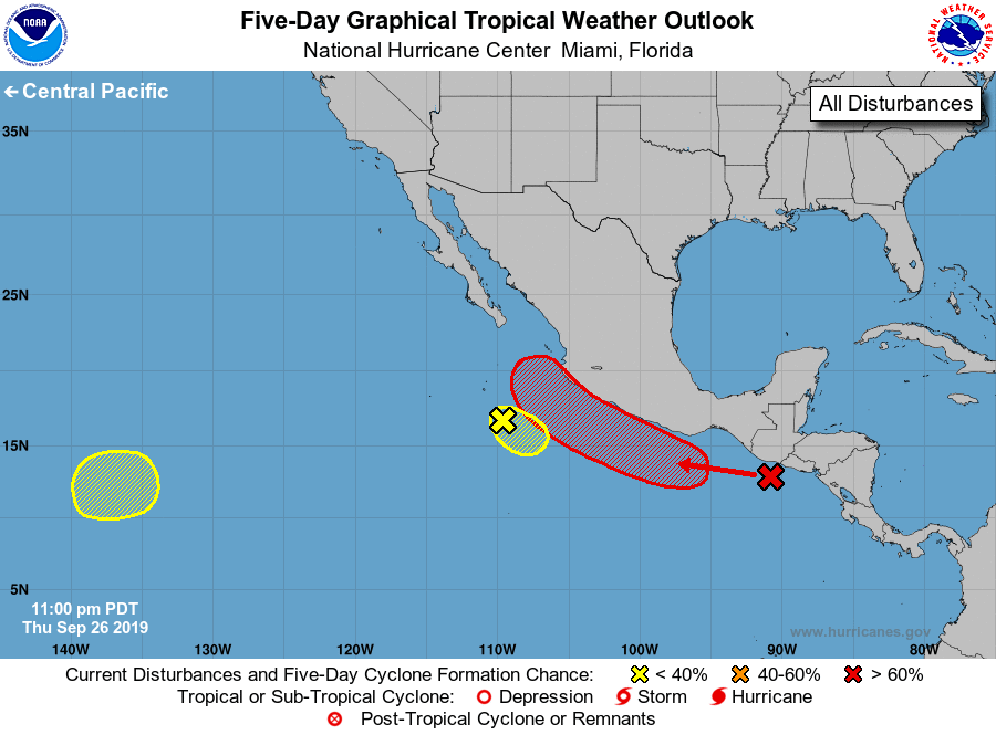
1. A small but well-defined low pressure system is located several
hundred miles south of the southern tip of the Baja California
peninsula. The low is currently producing no thunderstorms and
environmental conditions have become less conducive for tropical
cyclone formation. Some slight development is still possible later
today if thunderstorm activity increases while the system moves
quickly southeastward, however the low is expected to dissipate over
the weekend.
* Formation chance through 48 hours...low...30 percent.
* Formation chance through 5 days...low...30 percent.
2. A broad area of showers and thunderstorms is located near the
Pacific coasts of southern Mexico and Central America. This
disturbance is expected to move westward and will interact with an
elongated trough of low pressure just south of the coast of Mexico
during the next day or two. A tropical depression or tropical storm
is subsequently likely to form over the weekend or early next week
near the southern or southwestern coast of Mexico. Regardless of
development, the system is forecast to move west-northwestward to
northwestward along the coast of Mexico and will likely produce
heavy rainfall with the possibility of flash flooding and mudslides.
Heavy rainfall is also possible along the Pacific coast of Central
America through today.
* Formation chance through 48 hours...medium...50 percent.
* Formation chance through 5 days...high...80 percent.
3. An area of low pressure is expected to form over the far
southwestern portion of the eastern North Pacific by early next
week. Some gradual development is possible thereafter while the
system drifts slowly eastward or northeastward.
* Formation chance through 48 hours...low...near 0 percent.
* Formation chance through 5 days...low...30 percent.
Forecaster Zelinsky