ZCZC MIATWOEP ALL
TTAA00 KNHC DDHHMM
Tropical Weather Outlook
NWS National Hurricane Center Miami FL
1100 AM PDT Mon Sep 16 2019
For the eastern North Pacific...east of 140 degrees west longitude:
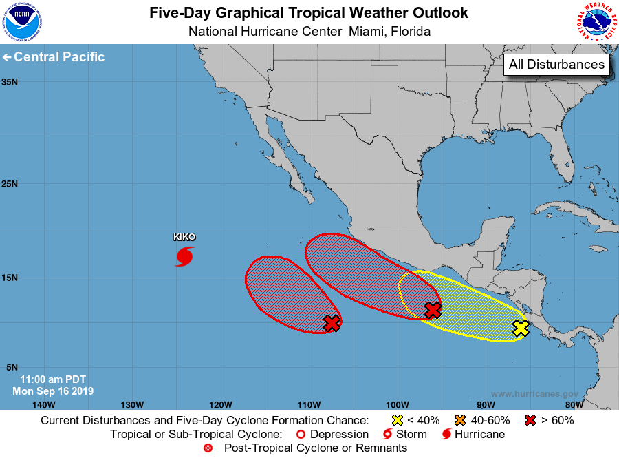
The National Hurricane Center is issuing advisories on Hurricane
Kiko, located in the southwestern part of the basin.
1. A small area of low pressure centered several hundred miles
south-southwest of Manzanillo, Mexico, continues to become better
organized. Any significant increase in organized thunderstorm
activity will likely result in the formation of a tropical
depression tonight or tomorrow. Beyond mid week, strong upper-level
winds from the system to the east could inhibit further development
while the low moves slowly west-northwestward or northwestward.
* Formation chance through 48 hours...high...80 percent.
* Formation chance through 5 days...high...80 percent.
2. Thunderstorm activity associated with a larger low pressure area
located a few hundred miles south-southwest of the Gulf of
Tehuantepec is also becoming better organized, with
satellite-derived winds indicating that the circulation is also
better defined. Environmental conditions are forecast to be
conducive for further development, and a tropical depression is
expected to form in a day or two as the system moves west-
northwestward near or a short distance offshore of the coast of
Mexico. Interests along the southwestern coast of Mexico should
monitor the progress of this system.
* Formation chance through 48 hours...high...90 percent.
* Formation chance through 5 days...high...90 percent.
3. A large area of cloudiness and showers near and just west of
Central America is associated with a tropical wave. Gradual
development of this system is possible during the next several days
while the wave moves westward or west-northwestward at 5 to 10 mph.
Locally heavy rainfall is also possible along the coasts of El
Salvador, Guatemala and southeastern Mexico this week.
* Formation chance through 48 hours...low...10 percent.
* Formation chance through 5 days...low...30 percent.
Forecaster Blake