ZCZC MIATWOEP ALL
TTAA00 KNHC DDHHMM
Tropical Weather Outlook
NWS National Hurricane Center Miami FL
500 AM PDT Mon Sep 16 2019
For the eastern North Pacific...east of 140 degrees west longitude:
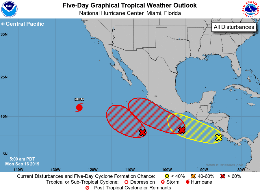
The National Hurricane Center is issuing advisories on Hurricane
Kiko, located in the southwestern part of the basin.
1. Showers and thunderstorms are showing signs of organization in
association with an area of low pressure centered several hundred
miles south-southwest of Manzanillo, Mexico. Conditions are
conducive for additional development, and a tropical depression
is likely to form within the next two to three days. After mid
week, this system is forecast to interact or merge with the
disturbance to its east, and further development could be limited.
* Formation chance through 48 hours...medium...60 percent.
* Formation chance through 5 days...high...70 percent.
2. An area of low pressure located a few hundred miles south-southwest
of the Gulf of Tehuantepec has become better defined overnight, and
the associated thunderstorm activity has also increased.
Environmental conditions are forecast to be conducive for further
development, and a tropical depression is expected to form around
the middle of the week as the system moves west-northwestward near,
or parallel to, the coast of Mexico.
* Formation chance through 48 hours...medium...60 percent.
* Formation chance through 5 days...high...80 percent.
3. A large area of cloudiness and showers near and just west of
Central America is associated with a tropical wave. Gradual
development of this system is possible during the next several days
while the wave moving westward or west-northwestward at 5 to 10 mph.
Locally heavy rainfall is also possible along the coasts of El
Salvador, Guatemala and southeastern Mexico this week.
* Formation chance through 48 hours...low...10 percent.
* Formation chance through 5 days...low...30 percent.
Forecaster Blake