ZCZC MIATWOEP ALL
TTAA00 KNHC DDHHMM
Tropical Weather Outlook
NWS National Hurricane Center Miami FL
500 PM PDT Thu Sep 12 2019
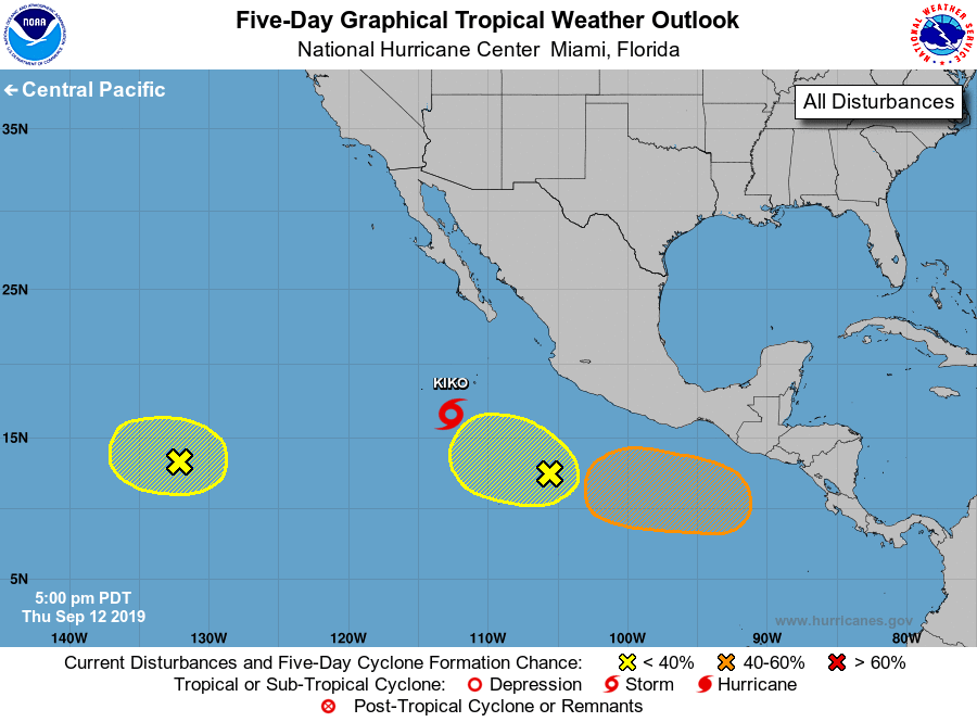
For the eastern North Pacific...east of 140 degrees west longitude:
The National Hurricane Center is issuing advisories on recently
named Tropical Storm Kiko, located several hundred miles
south-southwest of the southern tip of Baja California.
1. Showers and thunderstorms associated with a tropical wave located a
little more than 1500 miles west-southwest of the southern tip of
the Baja California peninsula have decreased since this morning.
Some gradual development of this system is still possible during the
next couple of days while the wave moves slowly westward at 5 to 10
mph. Strong upper-level winds are expected to limit the chance for
development by late this weekend.
* Formation chance through 48 hours...low...20 percent.
* Formation chance through 5 days...low...20 percent.
2. Another tropical wave, located a few hundred miles southwest of
Acapulco, Mexico, continues to produce an area of disorganized
showers and thunderstorms. Some slow development of this system is
possible through early next week as it moves westward or
west-northwestward at 5 to 10 mph.
* Formation chance through 48 hours...low...10 percent.
* Formation chance through 5 days...low...30 percent.
3. An area of low pressure is expected to form west of the coast of
Central America over the weekend. Environmental conditions are
forecast to be conducive for development and a tropical
depression could form early next week while the system moves
westward well south of the southern coast of Mexico.
* Formation chance through 48 hours...low...near 0 percent.
* Formation chance through 5 days...medium...60 percent.
Public Advisories on Tropical Storm Kiko are issued under WMO header
WTPZ33 KNHC and under AWIPS header MIATCPEP3.
Forecast/Advisories on Tropical Storm Kiko are issued under WMO
header WTPZ23 KNHC and under AWIPS header MIATCMEP3.
Forecaster Zelinsky