ZCZC MIATWOEP ALL
TTAA00 KNHC DDHHMM
Tropical Weather Outlook
NWS National Hurricane Center Miami FL
500 AM PDT Sun Aug 18 2019
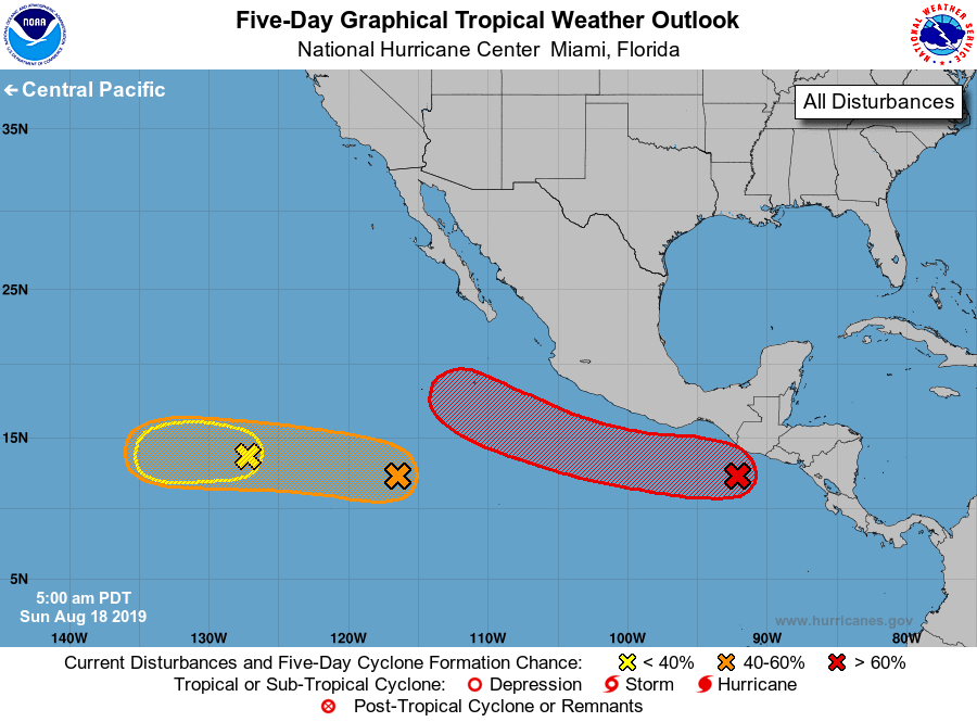
For the eastern North Pacific...east of 140 degrees west longitude:
1. Showers and thunderstorms associated with an area of low pressure
located a couple of hundred miles south-southwest of the coast of
Guatemala have changed little in organization since yesterday.
Environmental conditions are expected to become more conducive for
development during the next couple of days, and a tropical
depression is expected to form by Tuesday or Wednesday while the low
moves west-northwestward at about 10 mph parallel to the coast of
Mexico. Moisture associated with the low is forecast to produce
heavy rainfall and possible flash flooding across portions of El
Salvador, Guatemala, and southeastern Mexico during the next few
days.
* Formation chance through 48 hours...medium...50 percent.
* Formation chance through 5 days...high...90 percent.
2. A tropical wave located about 900 miles south-southwest of the
southern tip of the Baja California peninsula is producing
disorganized shower and thunderstorm activity. Environmental
conditions continue to support slow development, and this system has
the potential to become a tropical cyclone by the middle of the week
while it moves westward to west-northwestward at about 10 mph.
* Formation chance through 48 hours...low...20 percent.
* Formation chance through 5 days...medium...40 percent.
3. Shower and thunderstorm activity near another tropical wave located
about 1300 miles west-southwest of the southern tip of the Baja
California peninsula has decreased since yesterday. Any
development of this system during the next couple of days is
expected to be slow to occur while it moves slowly westward at
about 10 mph.
* Formation chance through 48 hours...low...10 percent.
* Formation chance through 5 days...low...10 percent.
Forecaster Berg