ZCZC MIATWOEP ALL
TTAA00 KNHC DDHHMM
Tropical Weather Outlook
NWS National Hurricane Center Miami FL
Issued by the NWS Weather Prediction Center College Park MD
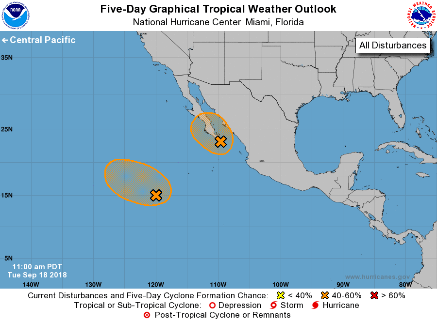
1100 AM PDT Tue Sep 18 2018
For the eastern North Pacific...east of 140 degrees west longitude:
1. A broad and elongated area of low pressure extending from near the
southern tip of the Baja California peninsula southwestward for a
few hundred miles continues to produce widespread but disorganized
showers and thunderstorms. Although environmental conditions appear
conducive for greater organization, the large size of the system
and interaction with land should inhibit the development potential
of this disturbance. However, this system could still become a
tropical depression during the next day or two while it moves near
Baja California Sur and the Gulf of California. Regardless of
development, this disturbance will likely produce very heavy
rainfall over Baja California Sur and other parts of northwestern
mainland Mexico over the next several days. The risk of mudlslides
and flash flooding may increase as the system tracks northward into
northwestern Mexico through Thursday. Interests in Baja California
Sur and northwestern Mexico should monitor the progress of this
disturbance.
* Formation chance through 48 hours...medium...40 percent.
* Formation chance through 5 days...medium...40 percent.
2. Another area of weak low pressure within an elongated trough is
located about 800 miles southwest of the southern tip of the Baja
California peninsula. Environmental conditions are expected to
be conducive for gradual development of this system over the
next several days while it moves slowly west-northwestward or
northwestward.
* Formation chance through 48 hours...low...20 percent.
* Formation chance through 5 days...medium...40 percent.
Forecaster Carbin/Blake