ZCZC MIATWOEP ALL
TTAA00 KNHC DDHHMM
Tropical Weather Outlook
NWS National Hurricane Center Miami FL
500 PM PDT Sat Aug 11 2018
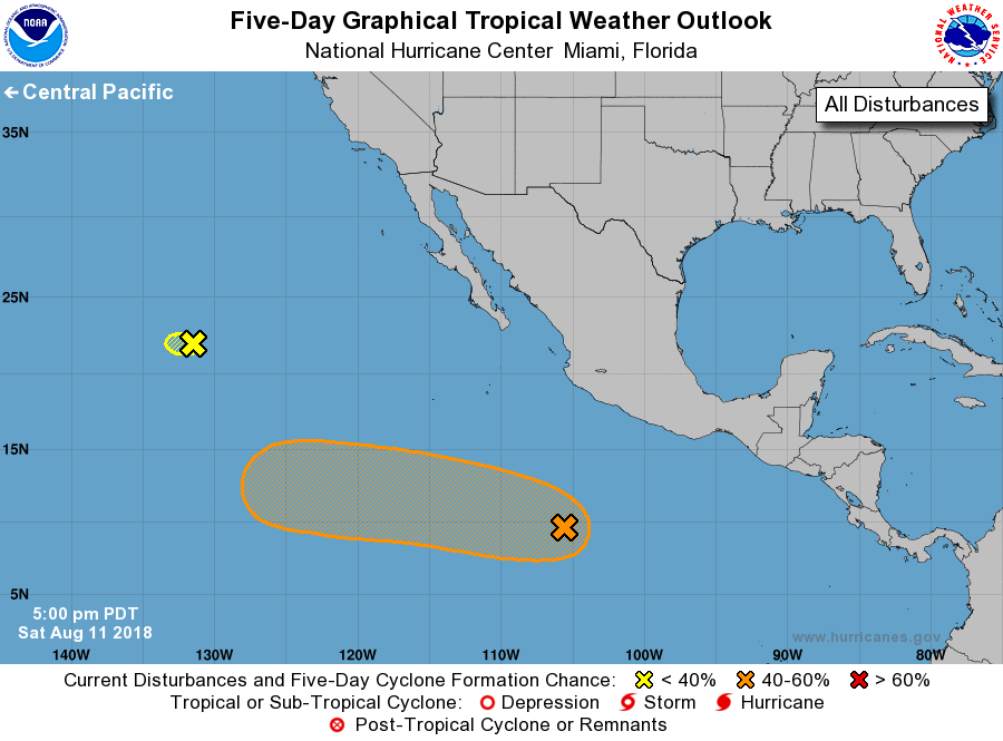
For the eastern North Pacific...east of 140 degrees west longitude:
1. A tropical wave located about 600 miles south of Manzanillo,
Mexico, continues to produce a large area of cloudiness, showers,
and thunderstorms. This system has shown some increase in
organization since yesterday, and additional development is
possible over the next couple of days. Upper-level winds appear to
become more conducive for development by the middle of next week,
and a tropical depression could form by that time while the wave
moves westward farther away from the coast of Mexico.
* Formation chance through 48 hours...low...20 percent.
* Formation chance through 5 days...medium...50 percent.
2. Showers and a few thunderstorms have redeveloped in association
with Post-Tropical Cyclone Kristy, located about 1400 miles west of
the southern tip of the Baja California peninsula. However, the
low is expected to continue moving westward over cold waters, and
regeneration into a tropical cyclone is not expected.
* Formation chance through 48 hours...low...10 percent.
* Formation chance through 5 days...low...10 percent.
Forecaster Berg