ZCZC MIATWOEP ALL
TTAA00 KNHC DDHHMM
Special Tropical Weather Outlook
NWS National Hurricane Center Miami FL
855 AM PDT Sat Aug 4 2018
For the eastern North Pacific...east of 140 degrees west longitude:
Special Tropical Weather Outlook issued to increase the development
chances of the disturbance south of the Gulf of Tehuantepec.
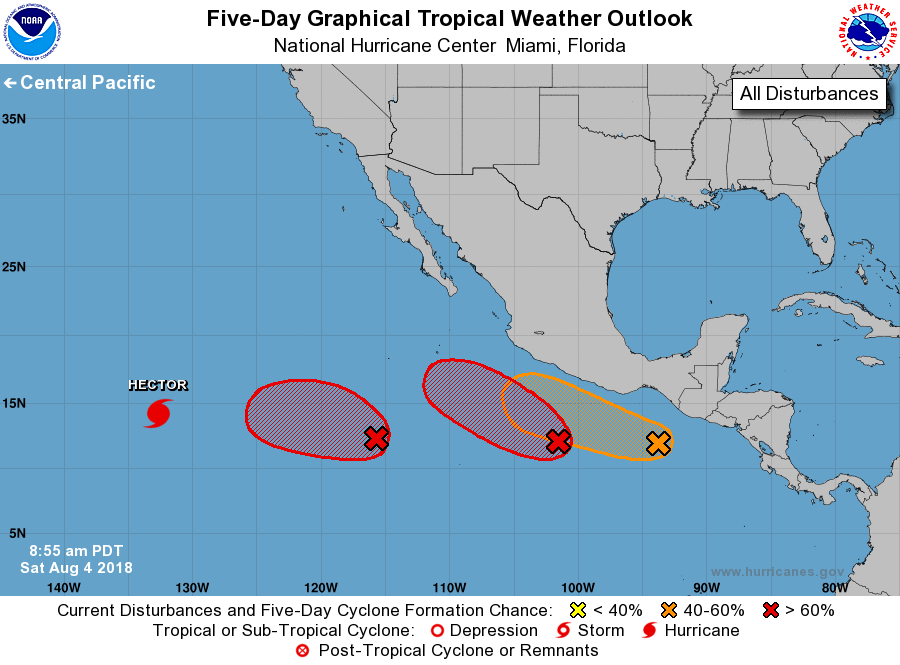
The National Hurricane Center is issuing advisories on Hurricane
Hector, located well southwest of Baja California Sur.
1. Showers and thunderstorms associated with an area of low
pressure centered about 825 miles south-southwest of the southern
tip of the Baja California peninsula continue to show signs of
organization. Environmental conditions are likely to support
additional development, and a tropical depression is expected to
form by early next week as the system moves slowly westward.
* Formation chance through 48 hours...high...70 percent.
* Formation chance through 5 days...high...90 percent.
2. A large area of disturbed weather centered several hundred miles
south of Acapulco, Mexico, has become better organized overnight.
Environmental conditions are conducive for signficant development,
and a tropical depression or tropical storm is expected to form
within the next day or two while the system moves west-northwestward
off the coast of Mexico.
* Formation chance through 48 hours...high...80 percent.
* Formation chance through 5 days...high...90 percent.
3. Updated: Satellite images indicate that a low pressure area has
formed a few hundred miles south of the Gulf of Tehuantepec, and
the system is already showing signs of organization. A tropical
depression could form over the next day or two while the system
moves westward or west-northwestward nearly parallel to the coast of
Mexico. Interests along the southern coast of Mexico should monitor
the progress of this system.
* Formation chance through 48 hours...medium...50 percent.
* Formation chance through 5 days...medium...60 percent.
Forecaster Blake