ZCZC MIATWOEP ALL
TTAA00 KNHC DDHHMM CCA
Tropical Weather Outlook...Corrected
NWS National Hurricane Center Miami FL
500 AM PDT Sun Jul 22 2018
Corrected spelling in first paragraph
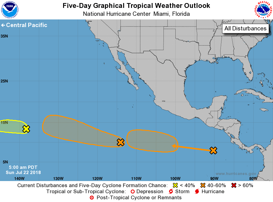
For the eastern North Pacific...east of 140 degrees west longitude:
1. A low pressure area located about 1150 miles east-southeast of the
Big island of Hawaii is producing showers and thunderstorms to the
east and southeast of the center. However, development of this
system is not expected due to strong upper-level winds. The low is
forecast to move westward at 10 to 15 mph and cross into the Central
Pacific basin this afternoon.
* Formation chance through 48 hours...low...10 percent.
* Formation chance through 5 days...low...10 percent.
2. A large area of disturbed weather is located several hundred miles
south and southwest of the southern tip of the Baja California
Peninsula. Although this system remains disorganized, environmental
conditions are expected to become somewhat conducive for
development, and a tropical depression could form by the middle part
of this week. This disturbance is expected to move toward the west
or west-northwest at 15 to 20 mph during the next several days.
* Formation chance through 48 hours...low...10 percent.
* Formation chance through 5 days...medium...50 percent.
3. A weak area of low pressure has formed several hundred miles
south-southeast of the Gulf of Tehuantepec. Little development of
the system is expected during the next couple of days. After that
time, environmental conditions are expected to be conducive for
gradual development while the system moves toward the west or
west-northwest well south of Mexico.
* Formation chance through 48 hours...low...near 0 percent.
* Formation chance through 5 days...medium...40 percent.
Forecaster Beven