ZCZC MIATWOEP ALL
TTAA00 KNHC DDHHMM
Tropical Weather Outlook
NWS National Hurricane Center Miami FL
500 PM PDT Sat Jul 21 2018
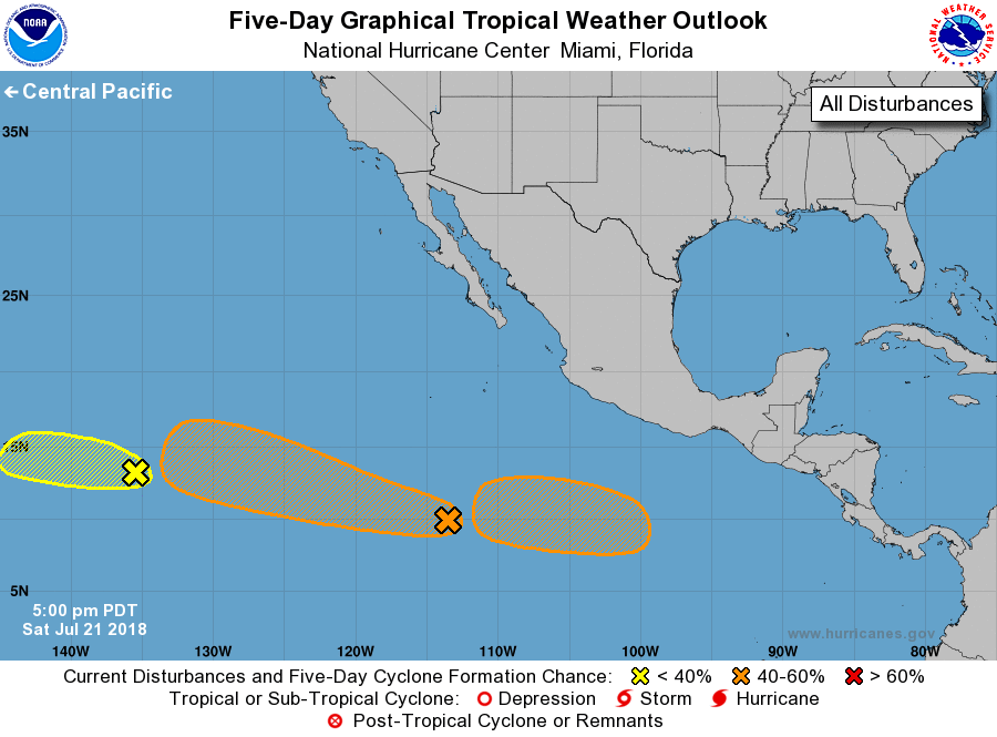
For the eastern North Pacific...east of 140 degrees west longitude:
1. Showers and thunderstorms have become less organized during the
past several hours in association with an area of low pressure
located about 1300 miles east-southeast of the Big Island of
Hawaii. Development of this system is unlikely due to strong
upper-level winds. The low is expected to move westward at
15 to 20 mph and cross into the Central Pacific basin by Sunday
night.
* Formation chance through 48 hours...low...20 percent.
* Formation chance through 5 days...low...20 percent.
2. A large area of disturbed weather is located several hundred miles
south of the southwestern coast of Mexico. Although there are
still no signs of organization, environmental conditions are
expected to become somewhat conducive for development, and a
tropical depression could form by the middle part of next week.
This disturbance is expected to move toward the west or
west-northwest at 15 to 20 mph during the next several days.
* Formation chance through 48 hours...low...10 percent.
* Formation chance through 5 days...medium...50 percent.
3. Another area of low pressure is expected to form in a few days
several hundred miles south of the southern coast of Mexico.
Environmental conditions appear to be conducive for gradual
development of this system while it moves toward the west or
west-northwest well south of Mexico.
* Formation chance through 48 hours...low...near 0 percent.
* Formation chance through 5 days...medium...40 percent.
Forecaster Cangialosi