ZCZC MIATWOEP ALL
TTAA00 KNHC DDHHMM
Tropical Weather Outlook
NWS National Hurricane Center Miami FL
1100 PM PDT Sun Jun 24 2018
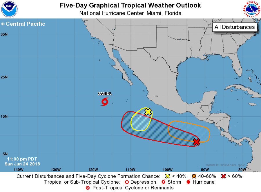
For the eastern North Pacific...east of 140 degrees west longitude:
The National Hurricane Center is issuing advisories on Tropical
Storm Daniel, located several hundred miles southwest of the
southern tip of the Baja California peninsula.
1. An elongated area of low pressure located a couple of hundred miles
south of Manzanillo, Mexico, is producing limited shower activity
over a broad area. Development of this system is becoming less
likely, and this disturbance is expected to merge with a tropical
wave approaching from the east in a couple of days.
* Formation chance through 48 hours...low...10 percent.
* Formation chance through 5 days...low...10 percent.
2. Satellite-derived winds and surface observations indicate that a
broad low pressure system has developed about 400 miles south of
Guatemala and southeastern Mexico. Environmental conditions are
expected to steadily become more conducive for development, and a
tropical depression is likely to form later this week week while the
system moves westward, well south of the coast of Mexico.
* Formation chance through 48 hours...low...10 percent.
* Formation chance through 5 days...high...70 percent.
3. A tropical wave is expected to move out of the Caribbean Sea and
into the eastern Pacific by Tuesday or Wednesday. Some subsequent
development of this system is possible, and a tropical depression
could form south of Central America or the Gulf of Tehuantepec by
the end the week while the system moves westward at 15 to 20 mph.
* Formation chance through 48 hours...low...near 0 percent.
* Formation chance through 5 days...medium..50 percent.
Forecaster Stewart