ZCZC MIATWOEP ALL
TTAA00 KNHC DDHHMM
Tropical Weather Outlook
NWS National Hurricane Center Miami FL
500 PM PDT Sun Jun 24 2018
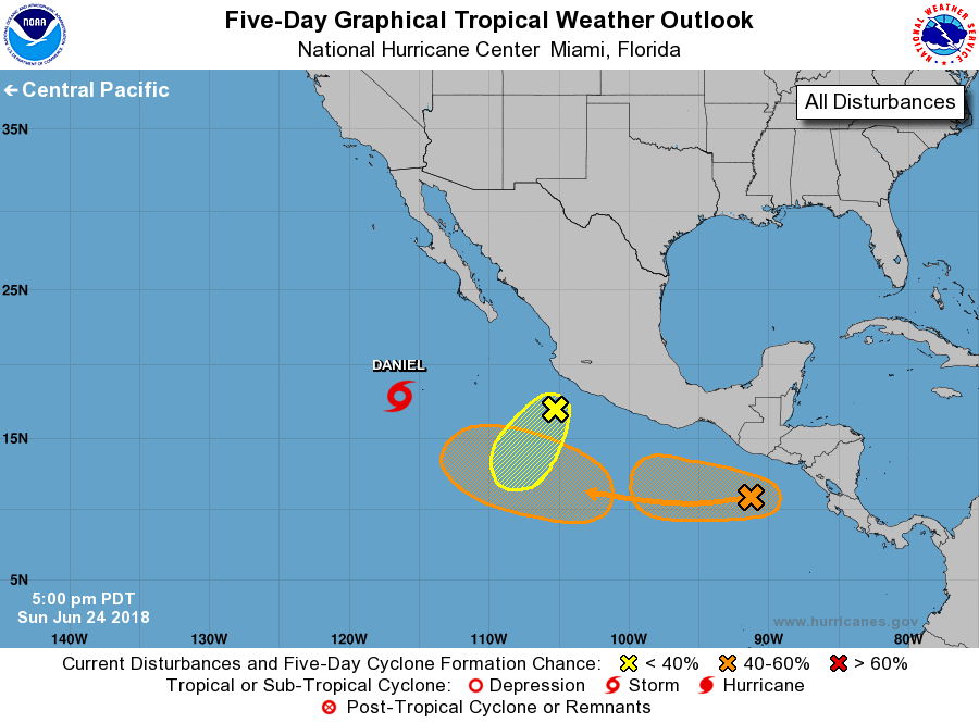
For the eastern North Pacific...east of 140 degrees west longitude:
The National Hurricane Center is issuing advisories on Tropical
Storm Daniel, located several hundred miles southwest of the
southern tip of the Baja California peninsula.
1. An elongated area of low pressure located a couple of hundred miles
south of Manzanillo, Mexico, is producing only limited shower and
thunderstorm activity over a broad area. Development of this system
is becoming less likely, but is still possible during the next two
to three days before it interacts and possibly merges with a
tropical wave approaching from the east.
* Formation chance through 48 hours...low...10 percent.
* Formation chance through 5 days...low...20 percent.
2. A tropical wave located to the south of Guatemala and southeastern
Mexico is producing disorganized showers and thunderstorms.
Environmental conditions appear conducive for gradual development,
and a tropical depression could form later this week week while the
system moves westward, well south of the coast of Mexico.
* Formation chance through 48 hours...low...near 0 percent.
* Formation chance through 5 days...medium...60 percent.
3. Another tropical wave is expected to move over the eastern Pacific
early this week. Some subsequent development of this system is
possible, and a tropical depression could form south of Central
America or the Gulf of Tehuantepec by the middle of the week as it
moves generally westward at 15 to 20 mph.
* Formation chance through 48 hours...low...near 0 percent.
* Formation chance through 5 days...medium..40 percent.
Forecaster Zelinsky