ZCZC MIATWOEP ALL
TTAA00 KNHC DDHHMM
Tropical Weather Outlook
NWS National Hurricane Center Miami FL
500 PM PDT Wed Sep 13 2017
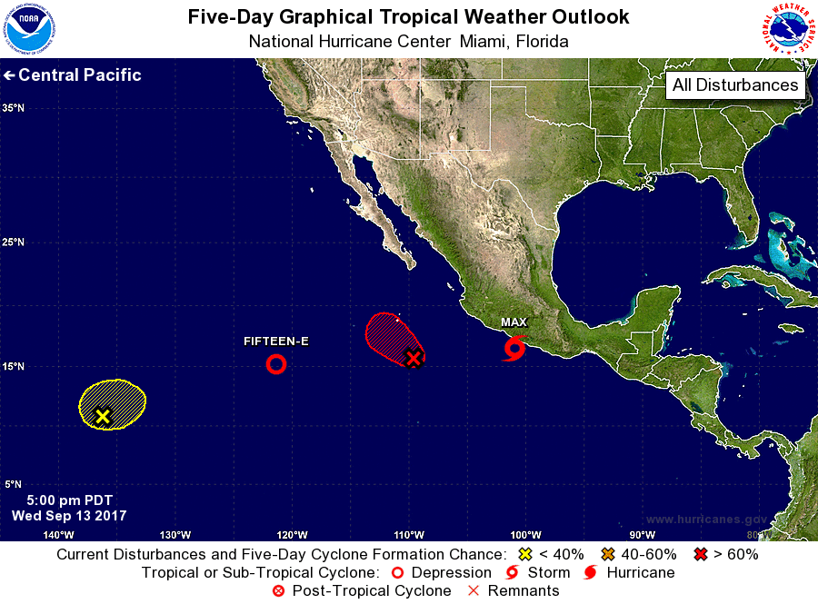
For the eastern North Pacific...east of 140 degrees west longitude:
The National Hurricane Center is issuing advisories on Tropical
Depression Fifteen-E, located several hundred miles southwest
of the southern tip of the Baja California peninsula, and on
recently upgraded Tropical Storm Max, located near the southwest
coast of Mexico.
1. A broad area of low pressure is located several hundred miles south
of the southern tip of the Baja California peninsula. Shower
activity continues to show signs of organization, and a tropical
depression is expected to form within the next couple of days while
the system moves slowly northwestward. For more information on
this system, please see High Seas Forecasts issued by the National
Weather Service.
* Formation chance through 48 hours...high...80 percent.
* Formation chance through 5 days...high...90 percent.
2. An area of low pressure located about 1500 miles east-southeast of
the Hawaiian Islands is producing persistent shower and thunderstorm
activity. Satellite imagery indicates that a well-defined center
does not currently exist and additional development, if any, is
expected to be slow to occur while this system moves little during
the next several days.
* Formation chance through 48 hours...low...10 percent.
* Formation chance through 5 days...low...20 percent.
High Seas Forecasts issued by the National Weather Service can be
found under AWIPS header NFDHSFEPI, WMO header FZPN02 KWBC, and on
the web at http://www.opc.ncep.noaa.gov/shtml/NFDHSFEPI.shtml.
Public Advisories on Max are issued under WMO header WTPZ31 KNHC
and under AWIPS header MIATCPEP1.
Forecast/Advisories on Max are issued under WMO header WTPZ21 KNHC
and under AWIPS header MIATCMEP1.
Forecaster Zelinsky