ZCZC MIATWOEP ALL
TTAA00 KNHC DDHHMM
Tropical Weather Outlook
NWS National Hurricane Center Miami FL
500 PM PDT Thu Jul 20 2017
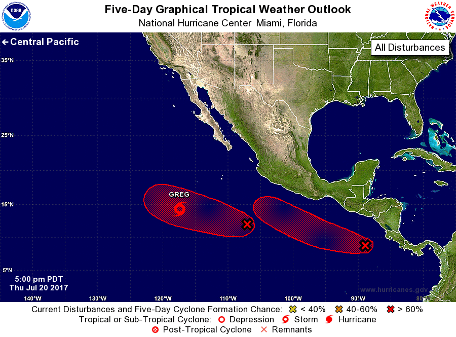
For the eastern North Pacific...east of 140 degrees west longitude:
The National Hurricane Center is issuing advisories on Tropical
Storm Greg, located several hundred miles southwest of the southern
tip of the Baja California peninsula. The National Hurricane Center
has issued its last advisory on Tropical Storm Fernanda, located
several hundred miles east of Hilo, Hawaii, and the last advisory on
Post-Tropical Cyclone Eight-E, located more than a thousand miles
west-southwest of the southern tip of the Baja California
peninsula. Future advisories on Fernanda will be issued by the
Central Pacific Hurricane Center in Honolulu, Hawaii.
1. Numerous showers and thunderstorms are associated with a broad area
of low pressure centered several hundred miles south-southwest of
Mexico. Environmental conditions are forecast to be conducive for
development of this system while it moves westward to
west-northwestward around 10 mph, and a tropical depression is
expected to form well southwest of Mexico over the weekend.
* Formation chance through 48 hours...high...70 percent.
* Formation chance through 5 days...high...90 percent.
2. Showers and thunderstorms associated with a tropical wave are
showing increasing signs of organization over the far eastern
Pacific southwest of Central America. Environmental conditions are
forecast to become increasingly favorable for development, and a
tropical depression is expected to form by early next week
while the system moves west-northwestward at 10 to 15 mph.
* Formation chance through 48 hours...medium...40 percent.
* Formation chance through 5 days...high...90 percent.
Public Advisories on Tropical Storm Fernanda are issued under WMO
header WTPA31 PHFO and under AWIPS header HFOTCPCP1.
Forecast/Advisories on Tropical Storm Fernanda are issued under WMO
header WTPA21 PHFO and under AWIPS header HFOTCMCP1.
Forecaster Landsea