ZCZC MIATWOEP ALL
TTAA00 KNHC DDHHMM
Tropical Weather Outlook
NWS National Hurricane Center Miami FL
1100 PM PDT Sun Jul 16 2017
For the eastern North Pacific...east of 140 degrees west longitude:
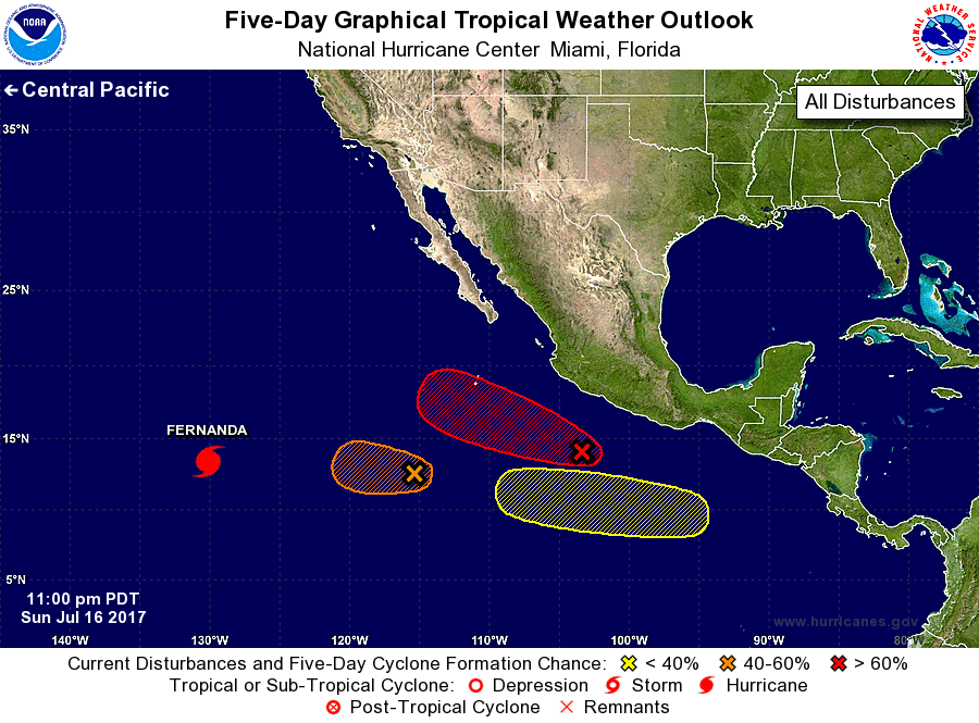
The National Hurricane Center is issuing advisories on Hurricane
Fernanda, located well to the west-southwest of the southern tip of
the Baja California peninsula.
1. Showers and thunderstorms associated with an area of low pressure
located about 350 miles south of Manzanillo, Mexico, continue to
show signs of organization. Although upper-level winds are not
particularly favorable for development, only a small increase in
organization of this system could lead to the formation of a
tropical depression during the next day or two while it moves
west-northwestward at 5 to 10 mph.
* Formation chance through 48 hours...high...70 percent.
* Formation chance through 5 days...high...80 percent.
2. An area of low pressure centered about 850 miles south-southwest of
the southern tip of the Baja peninsula has become better defined
during the past day or so. Although environmental conditions are
only marginally conducive, this system has the potential to become a
tropical depression during the next day or so before upper-level
winds become unfavorable for development. The low is expected
to move slowly to the west or west-northwest during the next few
days.
* Formation chance through 48 hours...medium...50 percent.
* Formation chance through 5 days...medium...50 percent.
3. Another area of low pressure is expected to form in the far
eastern Pacific Ocean south of Mexico late this week. Environmental
conditions appear conducive for some development of the system by
the weekend while it moves westward to west-northwestward at 10 to
15 mph.
* Formation chance through 48 hours...low...near 0 percent.
* Formation chance through 5 days...low...20 percent.
Forecaster Cangialosi