Skip Navigation Links
NOAA NOAA United States Department of Commerce

NHC Graphical Outlook Archive


« Earliest Available         ‹ Earlier         Later ›         Latest Available »
GIS Shapefiles
tab Eastern North Pacific tab tab Atlantic tab

View 2-Day Graphical Tropical Weather Outlook
Click for Atlantic Click for Atlantic

Tropical Weather Outlook Text

ZCZC MIATWOEP ALL
TTAA00 KNHC DDHHMM

TROPICAL WEATHER OUTLOOK
NWS NATIONAL HURRICANE CENTER MIAMI FL
500 PM PDT THU SEP 8 2016

For the eastern North Pacific...east of 140 degrees west longitude:

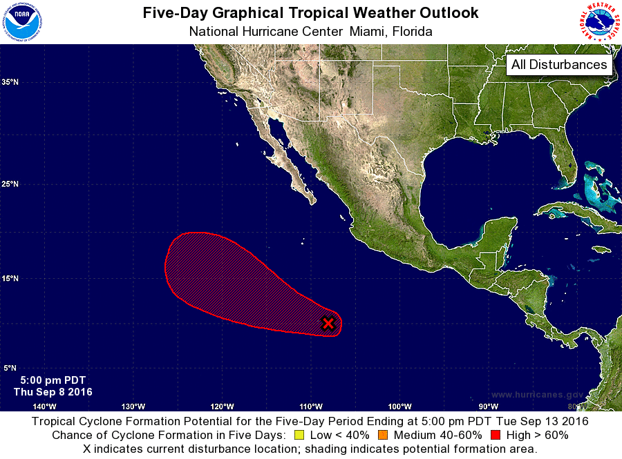
1. A broad area of low pressure associated with a tropical wave is
located about 700 miles south-southwest of Manzanillo, Mexico.  This
system is currently producing a large but disorganized area of
showers and thunderstorms.  However, environmental conditions are
expected to be conducive for gradual development during the next
several days, and a tropical depression is likely to form by early
next week while the low moves west-northwestward at 10 to 15 mph.
* Formation chance through 48 hours...low...30 percent
* Formation chance through 5 days...high...80 percent

Forecaster Brennan


List of Atlantic Outlooks (May 2023 - present)
List of East Pacific Outlooks (May 2023 - present)
List of Central Pacific Outlooks (May 2023 - present)
List of Atlantic Outlooks (July 2014 - April 2023)
List of East Pacific Outlooks (July 2014 - April 2023)
List of Central Pacific Outlooks (June 2019 - April 2023)
List of Atlantic Outlooks (June 2009 - June 2014)
List of East Pacific Outlooks (June 2009 - June 2014)