ZCZC MIATWOEP ALL
TTAA00 KNHC DDHHMM
TROPICAL WEATHER OUTLOOK
NWS NATIONAL HURRICANE CENTER MIAMI FL
500 AM PDT SAT SEP 3 2016
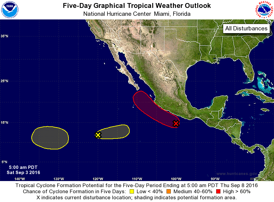
For the eastern North Pacific...east of 140 degrees west longitude:
1. An elongated area of low pressure continues to produce an extensive
area of disorganized cloudiness and showers, extending several
hundred miles south through southwest of the southern coast of
Mexico. Upper-level winds are expected to become more conducive for
development, and this area of disturbed weather is likely to
consolidate and become a tropical depression on Sunday or Monday
while it moves nearly parallel to the southwest coast of Mexico.
Regardless of development, gusty winds and heavy rains causing flash
floods and mud slides are expected in coastal portions of the
Mexican states of Oaxaca, Guerrero, Michoacan, Colima, Jalisco and
Nayarit this weekend into early next week. Interests in these areas
and Baja California Sur should monitor the progress of this
disturbance.
* Formation chance through 48 hours...high...70 percent
* Formation chance through 5 days...high...90 percent
2. A weak area of low pressure located about 1000 miles southwest of
the southern tip of the Baja California peninsula is producing a
few showers and thunderstorms. Development of this system is
not expected since the low is expected to be pulled eastward
into the circulation of the larger tropical disturbance near the
coast of Mexico later this weekend.
* Formation chance through 48 hours...low...10 percent
* Formation chance through 5 days...low...10 percent
3. An area of low pressure could form in a few days about 1500 miles
southwest of the southern tip of the Baja California peninsula.
Any development of this system should be slow to occur while the
system moves little.
* Formation chance through 48 hours...low...near 0 percent
* Formation chance through 5 days...low...20 percent
Forecaster Blake