ZCZC MIATWOEP ALL
TTAA00 KNHC DDHHMM
TROPICAL WEATHER OUTLOOK
NWS NATIONAL HURRICANE CENTER MIAMI FL
500 AM PDT MON AUG 22 2016
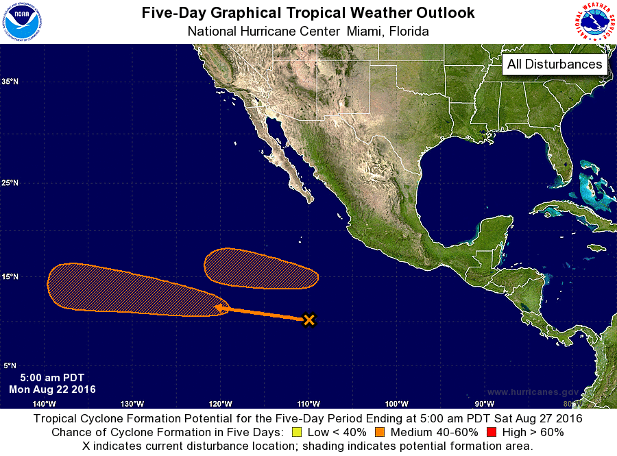
For the eastern North Pacific...east of 140 degrees west longitude:
The National Hurricane Center is issuing advisories on Tropical
Storm Kay, located several hundred miles west of the southern tip of
the Baja California peninsula.
1. An area of disturbed weather located about 850 miles south of the
southern tip of the Baja California peninsula is showing some signs
of organization. Environmental conditions are conducive for gradual
development of this system, and a tropical depression could form
later this week as the disturbance moves west-northwestward at
around 15 mph.
* Formation chance through 48 hours...low...10 percent
* Formation chance through 5 days...medium...50 percent
2. An area of low pressure is expected to form about 500 miles
south of the southern tip of the Baja California peninsula in a
couple of days. Environmental conditions are conducive for
development while this system moves generally westward at 10 to 15
mph.
* Formation chance through 48 hours...low...near 0 percent
* Formation chance through 5 days...medium...40 percent
Forecaster Kimberlain