


NHC Graphical Outlook Archive
|
« Earliest Available ‹ Earlier Later › Latest Available » |
GIS Shapefiles |
| Eastern North Pacific | Atlantic |
|
Tropical Weather Outlook Text
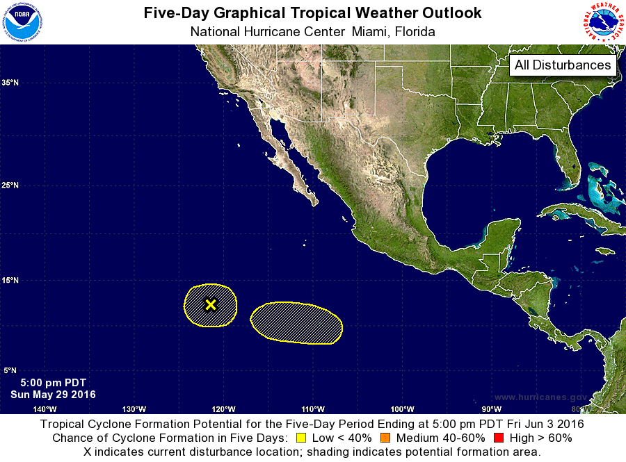
ZCZC MIATWOEP ALL
TTAA00 KNHC DDHHMM

TROPICAL WEATHER OUTLOOK
NWS NATIONAL HURRICANE CENTER MIAMI FL
500 PM PDT SUN MAY 29 2016

For the eastern North Pacific...east of 140 degrees west longitude:

1. A weak area of low pressure located about 1000 miles southwest of
the southern tip of the Baja California peninsula continues to
produce disorganized shower and thunderstorm activity.
Environmental conditions do not appear conducive for significant
development while this system meanders slowly during the next few
days.
* Formation chance through 48 hours...low...10 percent
* Formation chance through 5 days...low...10 percent

2. An area of low pressure is expected to develop around mid-week about
900 miles south of the southern tip of the Baja California
peninsula. Environmental conditions are forecast to be generally
conducive for some gradual development of this disturbance as it
moves slowly westward or west-northwestward.
* Formation chance through 48 hours...low...near 0 percent
* Formation chance through 5 days...low...20 percent

Forecaster Brennan
List of Atlantic Outlooks (May 2023 - present)
List of East Pacific Outlooks (May 2023 - present)
List of Central Pacific Outlooks (May 2023 - present)
List of Atlantic Outlooks (July 2014 - April 2023)
List of East Pacific Outlooks (July 2014 - April 2023)
List of Central Pacific Outlooks (June 2019 - April 2023)
List of Atlantic Outlooks (June 2009 - June 2014)
List of East Pacific Outlooks (June 2009 - June 2014)