


NHC Graphical Outlook Archive
|
« Earliest Available ‹ Earlier Later › Latest Available » |
GIS Shapefiles |
| Eastern North Pacific | Atlantic |
|
Tropical Weather Outlook Text
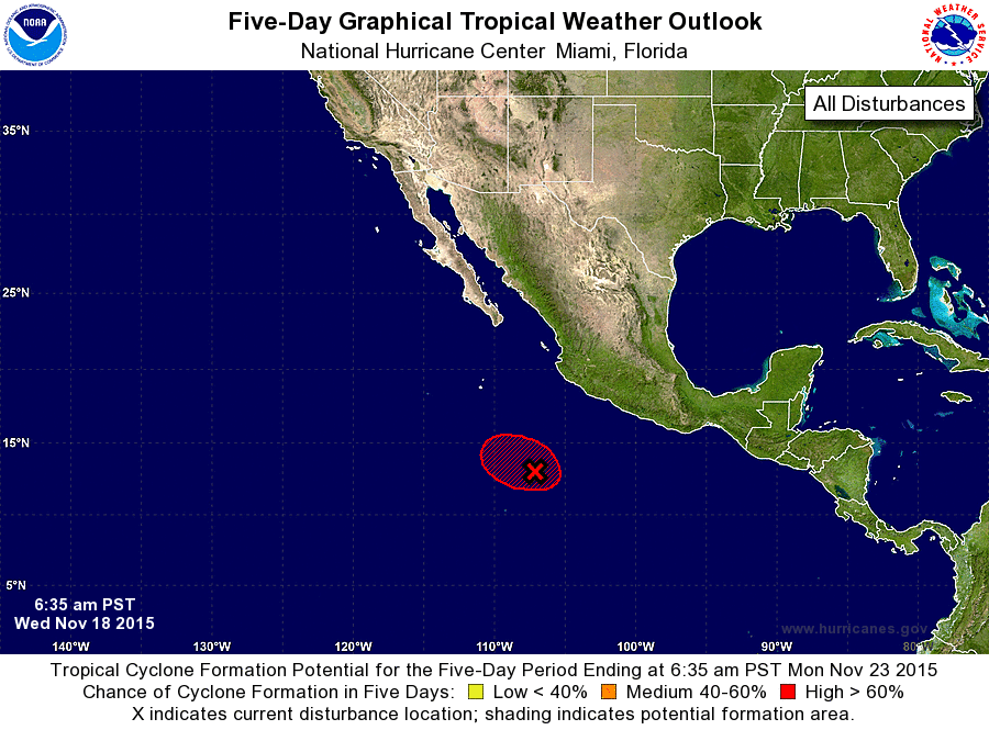
ZCZC MIATWOEP ALL
TTAA00 KNHC DDHHMM

SPECIAL TROPICAL WEATHER OUTLOOK
NWS NATIONAL HURRICANE CENTER MIAMI FL
635 AM PST WED NOV 18 2015

For the eastern North Pacific...east of 140 degrees west longitude:

Special tropical weather outlook issued to update the discussion of
the low pressure system south of Mexico.

1. Updated:  Showers and thunderstorms associated with an area of low
pressure located about 675 miles south-southeast of the southern tip
of the Baja California peninsula have continued to become better
organized this morning.  Satellite data indicate that a tropical
depression may be forming, and if the current development
trend continues advisories will be initiated on a tropical
depression later this morning or this afternoon.
* Formation chance through 48 hours...high...90 percent
* Formation chance through 5 days...high...90 percent

Forecaster Brown
List of Atlantic Outlooks (May 2023 - present)
List of East Pacific Outlooks (May 2023 - present)
List of Central Pacific Outlooks (May 2023 - present)
List of Atlantic Outlooks (July 2014 - April 2023)
List of East Pacific Outlooks (July 2014 - April 2023)
List of Central Pacific Outlooks (June 2019 - April 2023)
List of Atlantic Outlooks (June 2009 - June 2014)
List of East Pacific Outlooks (June 2009 - June 2014)