


NHC Graphical Outlook Archive
|
« Earliest Available ‹ Earlier Later › Latest Available » |
GIS Shapefiles |
| Eastern North Pacific | Atlantic |
|
Tropical Weather Outlook Text
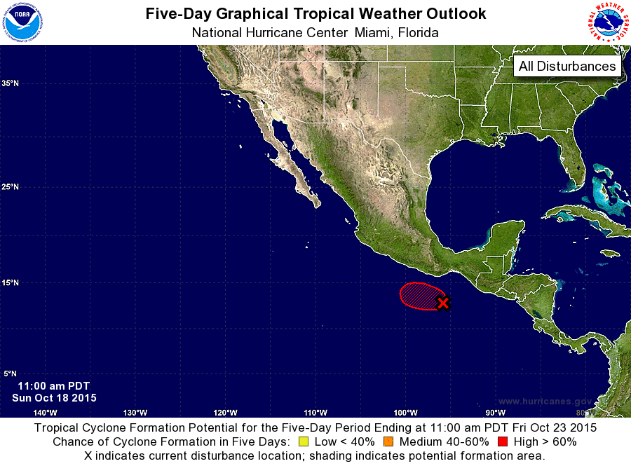
ZCZC MIATWOEP ALL
TTAA00 KNHC DDHHMM

TROPICAL WEATHER OUTLOOK
NWS NATIONAL HURRICANE CENTER MIAMI FL
1100 AM PDT SUN OCT 18 2015

For the eastern North Pacific...east of 140 degrees west longitude:

The National Hurricane Center is issuing advisories on Hurricane
Olaf, located more than 1500 miles east-southeast of the Big Island
of Hawaii.

1. Cloudiness and thunderstorms associated with a broad area of low
pressure located about 425 miles southeast of Acapulco, Mexico, have
become more concentrated since this time yesterday. Environmental
conditions are expected to be conducive for additional development,
and a tropical depression is likely to form early this week while
the low moves generally northwestward. Interests along the southern
coast of Mexico should monitor the progress of this system during
the next few days.
* Formation chance through 48 hours...medium...40 percent
* Formation chance through 5 days...high...80 percent

Forecaster Kimberlain
List of Atlantic Outlooks (May 2023 - present)
List of East Pacific Outlooks (May 2023 - present)
List of Central Pacific Outlooks (May 2023 - present)
List of Atlantic Outlooks (July 2014 - April 2023)
List of East Pacific Outlooks (July 2014 - April 2023)
List of Central Pacific Outlooks (June 2019 - April 2023)
List of Atlantic Outlooks (June 2009 - June 2014)
List of East Pacific Outlooks (June 2009 - June 2014)