


NHC Graphical Outlook Archive
|
« Earliest Available ‹ Earlier Later › Latest Available » |
GIS Shapefiles |
| Eastern North Pacific | Atlantic |
|
Tropical Weather Outlook Text
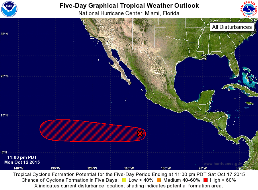
ZCZC MIATWOEP ALL
TTAA00 KNHC DDHHMM

TROPICAL WEATHER OUTLOOK
NWS NATIONAL HURRICANE CENTER MIAMI FL
1100 PM PDT MON OCT 12 2015

For the eastern North Pacific...east of 140 degrees west longitude:

1. A large, well-defined low pressure system is located about 600 miles
south-southwest of Manzanillo, Mexico.  Shower and thunderstorm
activity has increased since yesterday, and environmental conditions
are expected to gradually become more conducive for the development
of a tropical depression by the weekend while the low moves westward
at 10 to 15 mph.
* Formation chance through 48 hours...low...10 percent
* Formation chance through 5 days...high...80 percent

Forecaster Stewart
List of Atlantic Outlooks (May 2023 - present)
List of East Pacific Outlooks (May 2023 - present)
List of Central Pacific Outlooks (May 2023 - present)
List of Atlantic Outlooks (July 2014 - April 2023)
List of East Pacific Outlooks (July 2014 - April 2023)
List of Central Pacific Outlooks (June 2019 - April 2023)
List of Atlantic Outlooks (June 2009 - June 2014)
List of East Pacific Outlooks (June 2009 - June 2014)