


NHC Graphical Outlook Archive
|
« Earliest Available ‹ Earlier Later › Latest Available » |
GIS Shapefiles |
| Eastern North Pacific | Atlantic |
|
Tropical Weather Outlook Text
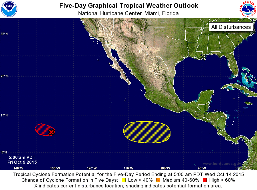
ZCZC MIATWOEP ALL
TTAA00 KNHC DDHHMM

TROPICAL WEATHER OUTLOOK
NWS NATIONAL HURRICANE CENTER MIAMI FL
500 AM PDT FRI OCT 9 2015

For the eastern North Pacific...east of 140 degrees west longitude:

1. Shower and thunderstorm activity have become better organized in
association with a low pressure area located about 1650 miles
east-southeast of the Hawaiian Islands.  Environmental conditions
are conducive, and a tropical depression is expected to form later
today or tonight while the system moves west-northwestward at about
15 mph.
* Formation chance through 48 hours...high...90 percent
* Formation chance through 5 days...high...90 percent

2. An area of low pressure is likely to form several hundred miles
south of southeastern Mexico late this weekend.  Environmental
conditions could become conducive for some development of
this system next week while it moves westward at about 10 mph.
* Formation chance through 48 hours...low...near 0 percent
* Formation chance through 5 days...low...30 percent

Forecaster Blake
List of Atlantic Outlooks (May 2023 - present)
List of East Pacific Outlooks (May 2023 - present)
List of Central Pacific Outlooks (May 2023 - present)
List of Atlantic Outlooks (July 2014 - April 2023)
List of East Pacific Outlooks (July 2014 - April 2023)
List of Central Pacific Outlooks (June 2019 - April 2023)
List of Atlantic Outlooks (June 2009 - June 2014)
List of East Pacific Outlooks (June 2009 - June 2014)