


NHC Graphical Outlook Archive
|
« Earliest Available ‹ Earlier Later › Latest Available » |
GIS Shapefiles |
| Eastern North Pacific | Atlantic |
|
Tropical Weather Outlook Text
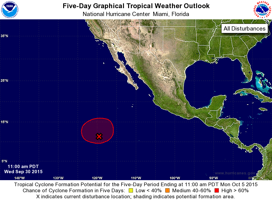
ZCZC MIATWOEP ALL
TTAA00 KNHC DDHHMM

TROPICAL WEATHER OUTLOOK
NWS NATIONAL HURRICANE CENTER MIAMI FL
1100 AM PDT WED SEP 30 2015

For the eastern North Pacific...east of 140 degrees west longitude:

The National Hurricane Center is issuing advisories on Tropical
Depression Marty, located just offshore of the southwestern coast of
Mexico.

1. A broad area of low pressure about 1000 miles south-southwest of the
southern tip of the Baja California peninsula continues to produce
disorganized showers and thunderstorms.  Environmental conditions
are expected to be conducive for gradual development, and a tropical
depression is likely to form by the weekend while the low drifts
northward or northeastward.  Upper-level winds could become less
favorable for development by early next week.
* Formation chance through 48 hours...medium...50 percent
* Formation chance through 5 days...high...80 percent

Forecaster Blake
List of Atlantic Outlooks (May 2023 - present)
List of East Pacific Outlooks (May 2023 - present)
List of Central Pacific Outlooks (May 2023 - present)
List of Atlantic Outlooks (July 2014 - April 2023)
List of East Pacific Outlooks (July 2014 - April 2023)
List of Central Pacific Outlooks (June 2019 - April 2023)
List of Atlantic Outlooks (June 2009 - June 2014)
List of East Pacific Outlooks (June 2009 - June 2014)