


NHC Graphical Outlook Archive
|
« Earliest Available ‹ Earlier Later › Latest Available » |
GIS Shapefiles |
| Eastern North Pacific | Atlantic |
|
Tropical Weather Outlook Text
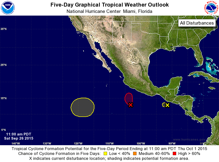
ZCZC MIATWOEP ALL
TTAA00 KNHC DDHHMM

TROPICAL WEATHER OUTLOOK
NWS NATIONAL HURRICANE CENTER MIAMI FL
1100 AM PDT SAT SEP 26 2015

For the eastern North Pacific...east of 140 degrees west longitude:

1. Satellite imagery indicates that shower and thunderstorm activity
associated with an area of low pressure located about 350 miles
southwest of Acapulco, Mexico is becoming better organized, and
that the low's circulation is becoming better defined.  If these
trends continue, advisories would be initiated on a tropical
depression later today or tonight while the low moves northwestward
or north-northwestward at about 5 to 10 mph. Interests along the
southern coast of Mexico should continue to monitor the progress of
this system.
* Formation chance through 48 hours...high...near 100 percent
* Formation chance through 5 days...high...near 100 percent

2. The concentrated area of thunderstorms associated with a small low
pressure system offshore of the coasts of Guatemala and El Salvador
has diminished this morning, and the area of low pressure appears to
be dissipating.  Upper-level winds are not conducive for
development, and tropical cyclone formation from this system is
unlikely.  Moisture related to this disturbance could still produce
locally heavy rains across portions of El Salvador and southern
Guatemala during the next day or so, with the rains possibly causing
life-threatening flash floods and mud slides.
* Formation chance through 48 hours...low...10 percent
* Formation chance through 5 days...low...10 percent

3. An area of low pressure could form by the middle of this week about
1000 miles southwest of the southern tip of the Baja California
peninsula.  Any development of this system later should be slow to
occur while the moves northward or northeastward.
* Formation chance through 48 hours...low...near 0 percent
* Formation chance through 5 days...low...20 percent

Forecaster Kimberlain
List of Atlantic Outlooks (May 2023 - present)
List of East Pacific Outlooks (May 2023 - present)
List of Central Pacific Outlooks (May 2023 - present)
List of Atlantic Outlooks (July 2014 - April 2023)
List of East Pacific Outlooks (July 2014 - April 2023)
List of Central Pacific Outlooks (June 2019 - April 2023)
List of Atlantic Outlooks (June 2009 - June 2014)
List of East Pacific Outlooks (June 2009 - June 2014)