


NHC Graphical Outlook Archive
|
« Earliest Available ‹ Earlier Later › Latest Available » |
GIS Shapefiles |
| Eastern North Pacific | Atlantic |
|
Tropical Weather Outlook Text
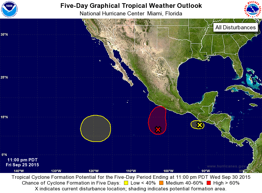
ZCZC MIATWOEP ALL
TTAA00 KNHC DDHHMM

TROPICAL WEATHER OUTLOOK
NWS NATIONAL HURRICANE CENTER MIAMI FL
1100 PM PDT FRI SEP 25 2015

For the eastern North Pacific...east of 140 degrees west longitude:

1. An area of low pressure is located about 400 miles south-southwest
of Acapulco, Mexico.  Showers and thunderstorms associated with this
system are gradually becoming better organized, and a tropical
depression is expected to form during the next day or two while the
low moves northward at about 5 mph.  Interests along the southern
coast of Mexico should monitor the progress of this system during
the next several days.
* Formation chance through 48 hours...high...80 percent
* Formation chance through 5 days...high...90 percent

2. A small low pressure system is producing a concentrated area of
showers and thunderstorms that extend about 100 miles off the
coasts of Guatemala and El Salvador.  The low is expected to
move little or drift westward during the next couple of days, and
further development appears unlikely due to its proximity to land
and unfavorable upper-level winds.  Regardless of tropical cyclone
development, this system will continue to produce heavy rains across
portions of El Salvador, southern Guatemala, and southeastern Mexico
during the next few days, along with gusty winds along the coast.
These rains could cause life-threatening flash floods and mudslides.
* Formation chance through 48 hours...low...30 percent
* Formation chance through 5 days...low...30 percent

3. An area of low pressure could form early next week about 1000 miles
southwest of the southern tip of the Baja California peninsula.
Some gradual development of this system is possible later next week
while it moves slowly northward.
* Formation chance through 48 hours...low...near 0 percent
* Formation chance through 5 days...low...20 percent

Forecaster Berg
List of Atlantic Outlooks (May 2023 - present)
List of East Pacific Outlooks (May 2023 - present)
List of Central Pacific Outlooks (May 2023 - present)
List of Atlantic Outlooks (July 2014 - April 2023)
List of East Pacific Outlooks (July 2014 - April 2023)
List of Central Pacific Outlooks (June 2019 - April 2023)
List of Atlantic Outlooks (June 2009 - June 2014)
List of East Pacific Outlooks (June 2009 - June 2014)