


NHC Graphical Outlook Archive
|
« Earliest Available ‹ Earlier Later › Latest Available » |
GIS Shapefiles |
| Eastern North Pacific | Atlantic |
|
Tropical Weather Outlook Text
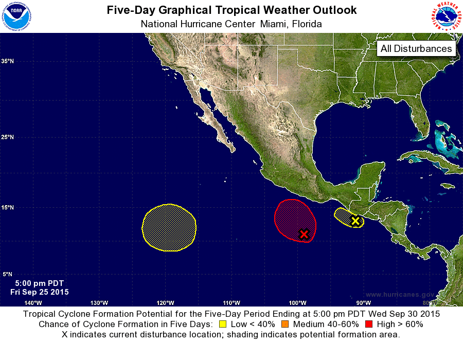
ZCZC MIATWOEP ALL
TTAA00 KNHC DDHHMM

TROPICAL WEATHER OUTLOOK
NWS NATIONAL HURRICANE CENTER MIAMI FL
500 PM PDT FRI SEP 25 2015

For the eastern North Pacific...east of 140 degrees west longitude:

1. Shower and thunderstorm activity has increased since yesterday in
association with a broad area of low pressure located just south of
the coast of Guatemala. However, further development of this low
appears unlikely due to interaction with land while it moves slowly
northward. Regardless of tropical cyclone development, this system
will continue to produce heavy rains across portions of southern
Guatemala, El Salvador, and southeastern Mexico during the next few
days, along with gusty winds along coastal portions of those areas.
These rains could cause life-threatening flash floods and mud
slides.
* Formation chance through 48 hours...low...30 percent
* Formation chance through 5 days...low...30 percent

2. Showers and thunderstorms associated with a broad area of low
pressure located about 400 miles south of Acapulco, Mexico, have
increased in organization since yesterday. Conditions appear
favorable for additional development, and this low is likely to
develop into a tropical depression during the next couple of days
while it moves slowly northward. Interests along the southern coast
of Mexico should monitor the progress of this system during the next
several days.
* Formation chance through 48 hours...high...70 percent
* Formation chance through 5 days...high...90 percent

3. An area of low pressure could form early next week about 1000 miles
southwest of the southern tip of the Baja California peninsula. Some
gradual development of this system is possible later next week while
it moves slowly northward.
* Formation chance through 48 hours...low...near 0 percent
* Formation chance through 5 days...low...20 percent

Forecaster Brennan
List of Atlantic Outlooks (May 2023 - present)
List of East Pacific Outlooks (May 2023 - present)
List of Central Pacific Outlooks (May 2023 - present)
List of Atlantic Outlooks (July 2014 - April 2023)
List of East Pacific Outlooks (July 2014 - April 2023)
List of Central Pacific Outlooks (June 2019 - April 2023)
List of Atlantic Outlooks (June 2009 - June 2014)
List of East Pacific Outlooks (June 2009 - June 2014)