


NHC Graphical Outlook Archive
|
« Earliest Available ‹ Earlier Later › Latest Available » |
GIS Shapefiles |
| Eastern North Pacific | Atlantic |
|
Tropical Weather Outlook Text
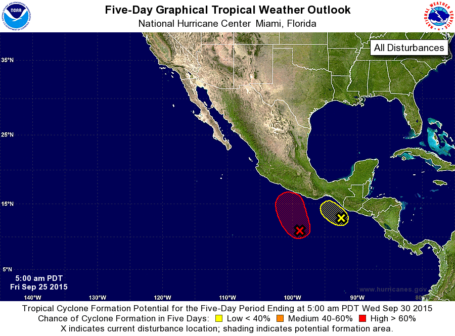
ZCZC MIATWOEP ALL
TTAA00 KNHC DDHHMM

TROPICAL WEATHER OUTLOOK
NWS NATIONAL HURRICANE CENTER MIAMI FL
500 AM PDT FRI SEP 25 2015

For the eastern North Pacific...east of 140 degrees west longitude:

1. An area of low pressure located just south of the Guatemala-Mexico
border is producing disorganized showers and thunderstorms. This
system is expected to drift northwestward during the next few days
and development should be limited due to its interaction with land.
Regardless of tropical cyclone formation, this system could produce
heavy rainfall over portions of El Salvador, southern Guatemala, and
southeastern Mexico during the next few days.
* Formation chance through 48 hours...low...20 percent
* Formation chance through 5 days...low...20 percent

2. A broad area of low pressure appears to be forming several hundred
miles south-southeast of Acapulco, Mexico.  This low is likely to
develop into a tropical depression by early next week and move
northward toward the southern coast of Mexico.  Interests in that
region should monitor the progress of this disturbance during the
next several days.
* Formation chance through 48 hours...low...30 percent
* Formation chance through 5 days...high...80 percent

Forecaster Cangialosi
List of Atlantic Outlooks (May 2023 - present)
List of East Pacific Outlooks (May 2023 - present)
List of Central Pacific Outlooks (May 2023 - present)
List of Atlantic Outlooks (July 2014 - April 2023)
List of East Pacific Outlooks (July 2014 - April 2023)
List of Central Pacific Outlooks (June 2019 - April 2023)
List of Atlantic Outlooks (June 2009 - June 2014)
List of East Pacific Outlooks (June 2009 - June 2014)