


NHC Graphical Outlook Archive
|
« Earliest Available ‹ Earlier Later › Latest Available » |
GIS Shapefiles |
| Eastern North Pacific | Atlantic |
|
Tropical Weather Outlook Text
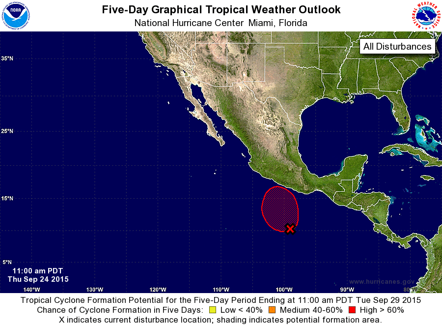
ZCZC MIATWOEP ALL
TTAA00 KNHC DDHHMM

TROPICAL WEATHER OUTLOOK
NWS NATIONAL HURRICANE CENTER MIAMI FL
1100 AM PDT THU SEP 24 2015

For the eastern North Pacific...east of 140 degrees west longitude:

1. A low pressure system is expected to form late this week within a
large area of disorganized cloudiness and thunderstorms extending
from the coast of Central America southwestward into the eastern
Pacific for several hundred miles.  The low is likely to develop
into a tropical depression by early next week several hundred miles
south or south-southwest of Acapulco, and move northward or
northeastward toward the southern coast of Mexico. Interests in that
region should monitor the progress of this disturbance during the
next several days.
* Formation chance through 48 hours...low...20 percent
* Formation chance through 5 days...high...80 percent

Forecaster Kimberlain
List of Atlantic Outlooks (May 2023 - present)
List of East Pacific Outlooks (May 2023 - present)
List of Central Pacific Outlooks (May 2023 - present)
List of Atlantic Outlooks (July 2014 - April 2023)
List of East Pacific Outlooks (July 2014 - April 2023)
List of Central Pacific Outlooks (June 2019 - April 2023)
List of Atlantic Outlooks (June 2009 - June 2014)
List of East Pacific Outlooks (June 2009 - June 2014)