


NHC Graphical Outlook Archive
|
« Earliest Available ‹ Earlier Later › Latest Available » |
GIS Shapefiles |
| Eastern North Pacific | Atlantic |
|
Tropical Weather Outlook Text
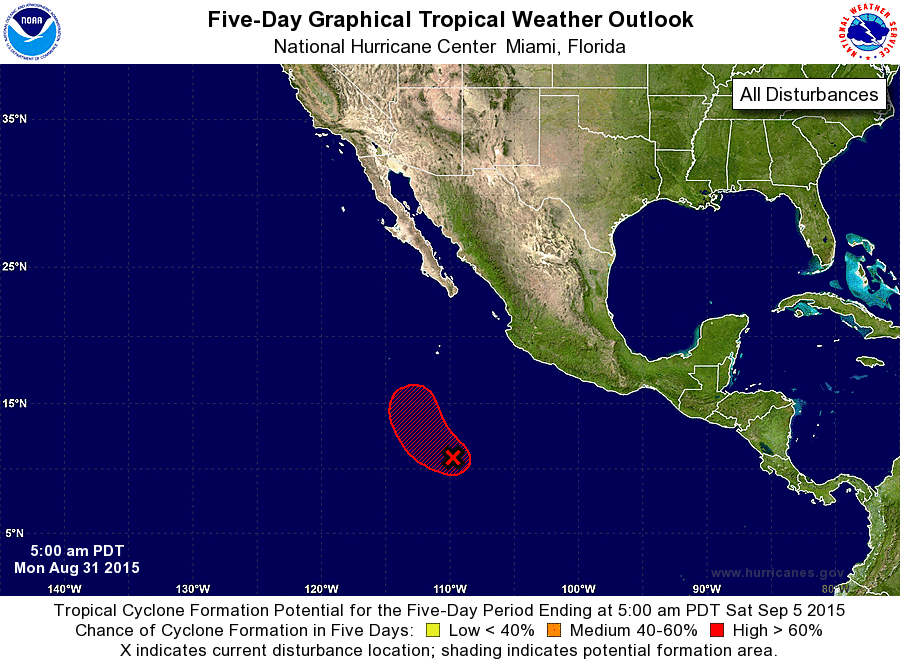
ZCZC MIATWOEP ALL
TTAA00 KNHC DDHHMM

TROPICAL WEATHER OUTLOOK
NWS NATIONAL HURRICANE CENTER MIAMI FL
500 AM PDT MON AUG 31 2015

For the eastern North Pacific...east of 140 degrees west longitude:

The National Hurricane Center is issuing advisories on major
Hurricane Jimena, located well east of the Big Island of Hawaii.

1. Showers and thunderstorms associated with an area of low pressure
located about 650 miles miles south-southwest of Manzanillo, Mexico,
have changed little in organization overnight.  Environmental
conditions appear conducive for development, and this system is
likely to become a tropical depression during the next day or two
while it begins to move northwestward at about 10 mph. If
development has not occurred by mid-week, less favorable upper-level
winds could make tropical cyclone formation less likely.
* Formation chance through 48 hours...high...80 percent
* Formation chance through 5 days...high...90 percent

Forecaster Brown
List of Atlantic Outlooks (May 2023 - present)
List of East Pacific Outlooks (May 2023 - present)
List of Central Pacific Outlooks (May 2023 - present)
List of Atlantic Outlooks (July 2014 - April 2023)
List of East Pacific Outlooks (July 2014 - April 2023)
List of Central Pacific Outlooks (June 2019 - April 2023)
List of Atlantic Outlooks (June 2009 - June 2014)
List of East Pacific Outlooks (June 2009 - June 2014)