


NHC Graphical Outlook Archive
|
« Earliest Available ‹ Earlier Later › Latest Available » |
GIS Shapefiles |
| Eastern North Pacific | Atlantic |
|
Tropical Weather Outlook Text
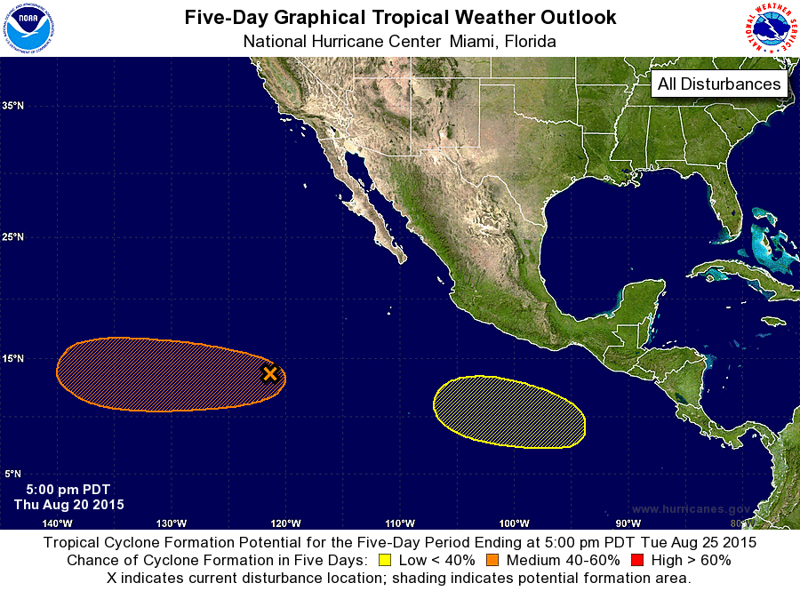
ZCZC MIATWOEP ALL
TTAA00 KNHC DDHHMM

TROPICAL WEATHER OUTLOOK
NWS NATIONAL HURRICANE CENTER MIAMI FL
500 PM PDT THU AUG 20 2015

For the eastern North Pacific...east of 140 degrees west longitude:

1. A tropical wave located about 1000 miles southwest of the southern
tip of the Baja California peninsula is producing disorganized
showers and a few thunderstorms.  Environmental conditions are
forecast to become conducive for gradual development of this system
during the next several days while the disturbance moves westward at
about 10 mph.
* Formation chance through 48 hours...low...10 percent
* Formation chance through 5 days...medium...50 percent

2. A low pressure area is forecast to form several hundred miles south
of the coast of Mexico early next week.  Environmental conditions
are expected to be conducive for subsequent slow development
of the system while it moves west-northwestward at 10 to 15 mph.
* Formation chance through 48 hours...low...near 0 percent
* Formation chance through 5 days...low...20 percent

Forecaster Brown
List of Atlantic Outlooks (May 2023 - present)
List of East Pacific Outlooks (May 2023 - present)
List of Central Pacific Outlooks (May 2023 - present)
List of Atlantic Outlooks (July 2014 - April 2023)
List of East Pacific Outlooks (July 2014 - April 2023)
List of Central Pacific Outlooks (June 2019 - April 2023)
List of Atlantic Outlooks (June 2009 - June 2014)
List of East Pacific Outlooks (June 2009 - June 2014)