


NHC Graphical Outlook Archive
|
« Earliest Available ‹ Earlier Later › Latest Available » |
GIS Shapefiles |
| Eastern North Pacific | Atlantic |
|
Tropical Weather Outlook Text
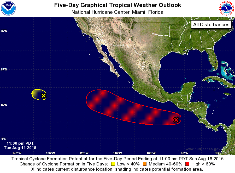
ZCZC MIATWOEP ALL
TTAA00 KNHC DDHHMM

TROPICAL WEATHER OUTLOOK
NWS NATIONAL HURRICANE CENTER MIAMI FL
1100 PM PDT TUE AUG 11 2015

For the eastern North Pacific...east of 140 degrees west longitude:

1. A tropical wave located south of the southeastern coast of Mexico
is producing disorganized cloudiness and showers. An area of low
pressure is forecast to form in association with this wave within a
couple of days a few hundred miles south-southwest of the coast of
Mexico. Environmental conditions should support development later
this week, and the system is very likely to become a tropical
cyclone by Sunday while it moves west-northwestward at about 15 mph.
* Formation chance through 48 hours...low...20 percent
* Formation chance through 5 days...high...90 percent

2. Shower and thunderstorm activity has become minimal in association
with a low pressure area located about 1500 miles west-southwest of
the southern tip of the Baja California peninsula. Development of
the low seems unlikely before environmental conditions become
unfavorable on Wednesday while the low moves westward at about 10
mph.
* Formation chance through 48 hours...low...10 percent
* Formation chance through 5 days...low...10 percent

Forecaster Blake
List of Atlantic Outlooks (May 2023 - present)
List of East Pacific Outlooks (May 2023 - present)
List of Central Pacific Outlooks (May 2023 - present)
List of Atlantic Outlooks (July 2014 - April 2023)
List of East Pacific Outlooks (July 2014 - April 2023)
List of Central Pacific Outlooks (June 2019 - April 2023)
List of Atlantic Outlooks (June 2009 - June 2014)
List of East Pacific Outlooks (June 2009 - June 2014)