


NHC Graphical Outlook Archive
|
« Earliest Available ‹ Earlier Later › Latest Available » |
GIS Shapefiles |
| Eastern North Pacific | Atlantic |
|
Tropical Weather Outlook Text
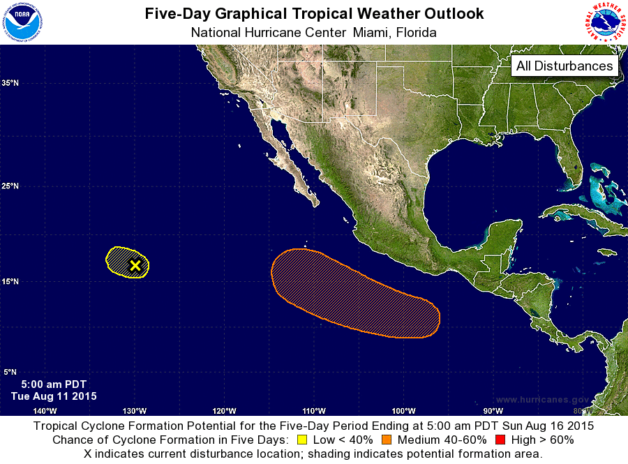
ZCZC MIATWOEP ALL
TTAA00 KNHC DDHHMM

TROPICAL WEATHER OUTLOOK
NWS NATIONAL HURRICANE CENTER MIAMI FL
500 AM PDT TUE AUG 11 2015

For the eastern North Pacific...east of 140 degrees west longitude:

1. Showers and thunderstorms associated with an area of low pressure
located about 1400 miles west-southwest of the southern tip of the
Baja California peninsula have increased since yesterday. However,
significant development of this system is unlikely due to
increasingly unfavorable upper-level winds while it moves westward
at around 10 mph.
* Formation chance through 48 hours...low...20 percent
* Formation chance through 5 days...low...20 percent

2. An area of low pressure is forecast to form a few hundred miles
south of Mexico in a few days. Environmental conditions should
support gradual development of this system by the weekend while it
moves west-northwestward at about 15 mph.
* Formation chance through 48 hours...low...near 0 percent
* Formation chance through 5 days...medium...50 percent

Forecaster Brennan
List of Atlantic Outlooks (May 2023 - present)
List of East Pacific Outlooks (May 2023 - present)
List of Central Pacific Outlooks (May 2023 - present)
List of Atlantic Outlooks (July 2014 - April 2023)
List of East Pacific Outlooks (July 2014 - April 2023)
List of Central Pacific Outlooks (June 2019 - April 2023)
List of Atlantic Outlooks (June 2009 - June 2014)
List of East Pacific Outlooks (June 2009 - June 2014)