


NHC Graphical Outlook Archive
|
« Earliest Available ‹ Earlier Later › Latest Available » |
GIS Shapefiles |
| Eastern North Pacific | Atlantic |
|
Tropical Weather Outlook Text
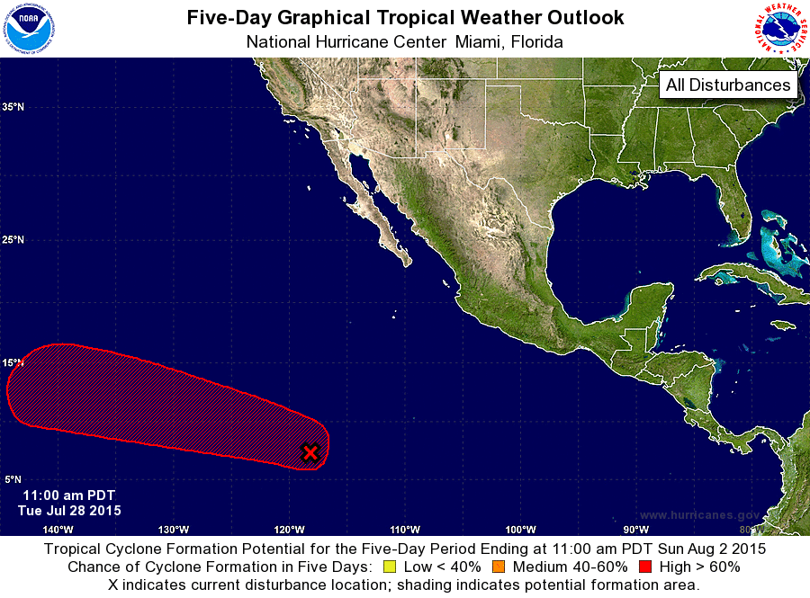
ZCZC MIATWOEP ALL
TTAA00 KNHC DDHHMM

TROPICAL WEATHER OUTLOOK
NWS NATIONAL HURRICANE CENTER MIAMI FL
1100 AM PDT TUE JUL 28 2015

For the eastern North Pacific...east of 140 degrees west longitude:

The National Hurricane Center is issuing advisories on Tropical
Depression Eight-E, located well to the west-southwest of the
southern tip of the Baja California peninsula.

1. A broad low pressure system located about 1200 miles south-
southwest of the southern tip of the Baja California peninsula
continues to produce a large area of cloudiness and showers.
Environmental conditions are expected to gradually become more
conducive for development over the next several days, and this
system is likely to become a tropical depression by this weekend
while it moves westward at about 15 mph.
* Formation chance through 48 hours...low...10 percent
* Formation chance through 5 days...high...90 percent

Public Advisories on Tropical Depression Eight-E are issued under
WMO header WTPZ33 KNHC and under AWIPS header MIATCPEP3.
Forecast/Advisories on Tropical Depression Eight-E are issued under
WMO header WTPZ23 KNHC and under AWIPS header MIATCMEP3.

Forecaster Stewart
List of Atlantic Outlooks (May 2023 - present)
List of East Pacific Outlooks (May 2023 - present)
List of Central Pacific Outlooks (May 2023 - present)
List of Atlantic Outlooks (July 2014 - April 2023)
List of East Pacific Outlooks (July 2014 - April 2023)
List of Central Pacific Outlooks (June 2019 - April 2023)
List of Atlantic Outlooks (June 2009 - June 2014)
List of East Pacific Outlooks (June 2009 - June 2014)