


NHC Graphical Outlook Archive
|
« Earliest Available ‹ Earlier Later › Latest Available » |
GIS Shapefiles |
| Eastern North Pacific | Atlantic |
|
Tropical Weather Outlook Text
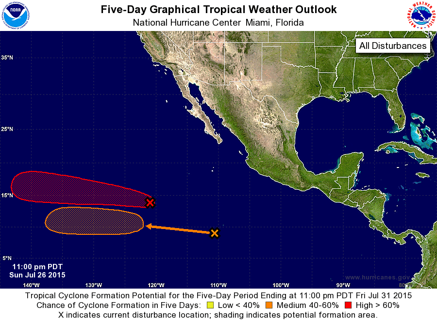
ZCZC MIATWOEP ALL
TTAA00 KNHC DDHHMM

TROPICAL WEATHER OUTLOOK
NWS NATIONAL HURRICANE CENTER MIAMI FL
1100 PM PDT SUN JUL 26 2015

For the eastern North Pacific...east of 140 degrees west longitude:

1. Shower activity associated with a low pressure system located about
1000 miles southwest of the southern tip of the Baja California
peninsula is limited and disorganized. Even though environmental
conditions are expected to be only somewhat conducive for
development, a tropical depression is still likely to form around
mid-week while the low moves west-northwestward at around 15 mph.
* Formation chance through 48 hours...medium...40 percent
* Formation chance through 5 days...high...70 percent

2. Showers and thunderstorms associated with a tropical wave located
several hundred miles south of the southern tip of the Baja
California peninsula have increased since yesterday.  Environmental
conditions are forecast to be conducive for slow development while
the disturbance moves generally westward this week.
* Formation chance through 48 hours...low...near 0 percent
* Formation chance through 5 days...medium...40 percent

Forecaster Kimberlain
List of Atlantic Outlooks (May 2023 - present)
List of East Pacific Outlooks (May 2023 - present)
List of Central Pacific Outlooks (May 2023 - present)
List of Atlantic Outlooks (July 2014 - April 2023)
List of East Pacific Outlooks (July 2014 - April 2023)
List of Central Pacific Outlooks (June 2019 - April 2023)
List of Atlantic Outlooks (June 2009 - June 2014)
List of East Pacific Outlooks (June 2009 - June 2014)