


NHC Graphical Outlook Archive
|
« Earliest Available ‹ Earlier Later › Latest Available » |
GIS Shapefiles |
| Eastern North Pacific | Atlantic |
|
Tropical Weather Outlook Text
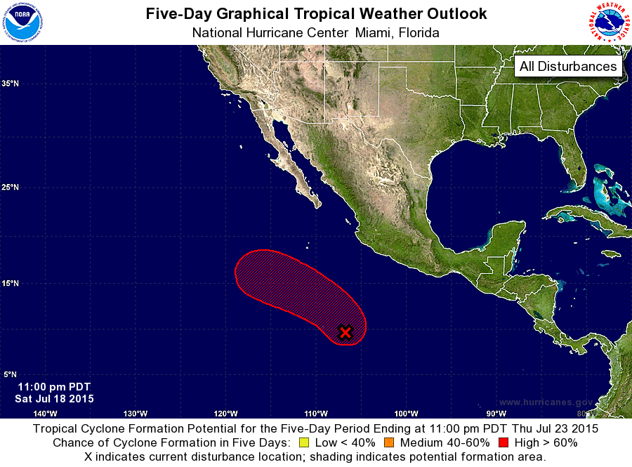
ZCZC MIATWOEP ALL
TTAA00 KNHC DDHHMM

TROPICAL WEATHER OUTLOOK
NWS NATIONAL HURRICANE CENTER MIAMI FL
1100 PM PDT SAT JUL 18 2015

For the eastern North Pacific...east of 140 degrees west longitude:

The National Hurricane Center has issued the last advisory on
Post-Tropical Cyclone Dolores, located a few hundred miles
west-southwest of Punta Eugenia, Mexico.

1. Showers and thunderstorms are gradually showing signs of
organization in association with a low pressure system located about
700 miles southwest of Acapulco, Mexico. Environmental conditions
are expected to be conducive for development, and a tropical
depression is likely to form during the next day or two while the
system moves northwestward at about 10 mph well offshore of the
coast of Mexico.
* Formation chance through 48 hours...medium...60 percent
* Formation chance through 5 days...high...90 percent

Forecaster Stewart
List of Atlantic Outlooks (May 2023 - present)
List of East Pacific Outlooks (May 2023 - present)
List of Central Pacific Outlooks (May 2023 - present)
List of Atlantic Outlooks (July 2014 - April 2023)
List of East Pacific Outlooks (July 2014 - April 2023)
List of Central Pacific Outlooks (June 2019 - April 2023)
List of Atlantic Outlooks (June 2009 - June 2014)
List of East Pacific Outlooks (June 2009 - June 2014)