


NHC Graphical Outlook Archive
|
« Earliest Available ‹ Earlier Later › Latest Available » |
GIS Shapefiles |
| Eastern North Pacific | Atlantic |
|
Tropical Weather Outlook Text
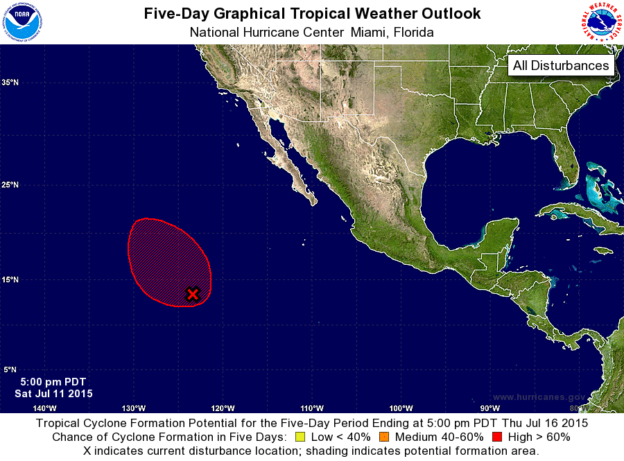
ZCZC MIATWOEP ALL
TTAA00 KNHC DDHHMM

TROPICAL WEATHER OUTLOOK
NWS NATIONAL HURRICANE CENTER MIAMI FL
500 PM PDT SAT JUL 11 2015

For the eastern North Pacific...east of 140 degrees west longitude:

The National Hurricane Center is issuing advisories on Tropical
Depression Five-E, located a few hundred miles south of Acapulco,
Mexico.

1. Shower activity associated with a low pressure area located about
1100 miles southwest of the southern tip of Baja California Sur is
currently disorganized, and recent satellite wind data indicate
that the circulation is poorly defined.  However, environmental
conditions remain conducive for a tropical depression to form Sunday
or Monday while the system moves toward the west-northwest at about
10 mph. After that time, the system could encounter a more stable
air mass with development becoming less likely.
* Formation chance through 48 hours...high...80 percent
* Formation chance through 5 days...high...80 percent

Public Advisories on Tropical Depression Five-E are issued under
WMO header WTPZ35 KNHC and under AWIPS header MIATCPEP5.
Forecast/Advisories are issued under WMO header WTPZ25 KNHC and
AWIPS header MIATCMEP5.

Forecaster Beven
List of Atlantic Outlooks (May 2023 - present)
List of East Pacific Outlooks (May 2023 - present)
List of Central Pacific Outlooks (May 2023 - present)
List of Atlantic Outlooks (July 2014 - April 2023)
List of East Pacific Outlooks (July 2014 - April 2023)
List of Central Pacific Outlooks (June 2019 - April 2023)
List of Atlantic Outlooks (June 2009 - June 2014)
List of East Pacific Outlooks (June 2009 - June 2014)