


NHC Graphical Outlook Archive
|
« Earliest Available ‹ Earlier Later › Latest Available » |
GIS Shapefiles |
| Eastern North Pacific | Atlantic |
|
Tropical Weather Outlook Text
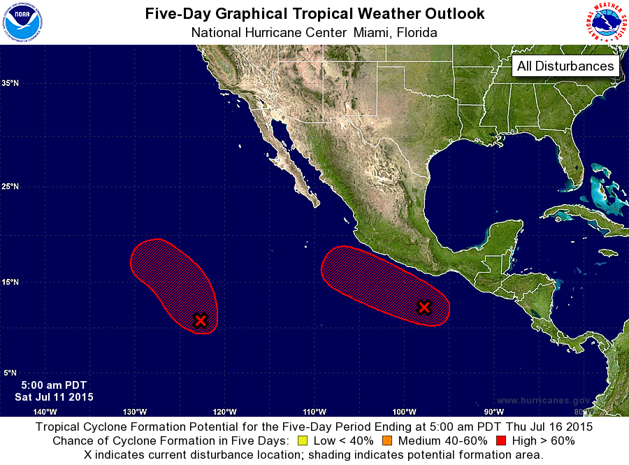
ZCZC MIATWOEP ALL
TTAA00 KNHC DDHHMM

TROPICAL WEATHER OUTLOOK
NWS NATIONAL HURRICANE CENTER MIAMI FL
500 AM PDT SAT JUL 11 2015

For the eastern North Pacific...east of 140 degrees west longitude:

1. An area of low pressure located about 1200 miles southwest of the
southern tip of Baja California Sur is moving north-northwestward at
about 10 mph.  Shower and thunderstorm activity continues to show
signs of organization, and conditions are expected to be conducive
for the development of a tropical depression during tonight
or Sunday.
* Formation chance through 48 hours...high...90 percent
* Formation chance through 5 days...high...90 percent

2. Satellite images indicate that showers and thunderstorms associated
with a low pressure system located about 300 miles south-southeast
of Acapulco, Mexico have become better organized and a tropical
depression appears to be forming. If the current trend continues,
advisories will be initiated on this system later this morning.
Interests along the southern and southwestern coasts of Mexico
should monitor the progress of this disturbance.
* Formation chance through 48 hours...high...90 percent
* Formation chance through 5 days...high...90 percent

Forecaster Cangialosi
List of Atlantic Outlooks (May 2023 - present)
List of East Pacific Outlooks (May 2023 - present)
List of Central Pacific Outlooks (May 2023 - present)
List of Atlantic Outlooks (July 2014 - April 2023)
List of East Pacific Outlooks (July 2014 - April 2023)
List of Central Pacific Outlooks (June 2019 - April 2023)
List of Atlantic Outlooks (June 2009 - June 2014)
List of East Pacific Outlooks (June 2009 - June 2014)