


NHC Graphical Outlook Archive
|
« Earliest Available ‹ Earlier Later › Latest Available » |
GIS Shapefiles |
| Eastern North Pacific | Atlantic |
|
Tropical Weather Outlook Text
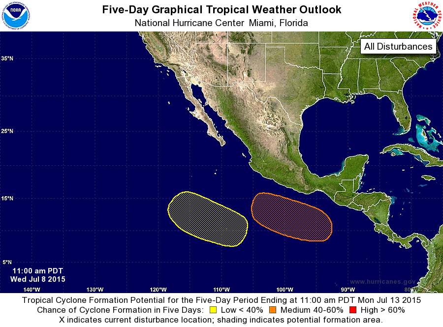
ZCZC MIATWOEP ALL
TTAA00 KNHC DDHHMM

TROPICAL WEATHER OUTLOOK
NWS NATIONAL HURRICANE CENTER MIAMI FL
1100 AM PDT WED JUL 8 2015

For the eastern North Pacific...east of 140 degrees west longitude:

1. An area of low pressure is expected to form several hundred miles
south of the coast of southern Mexico later this week.  Some
development of this system is expected this weekend and early next
week while it moves west-northwestward.
* Formation chance through 48 hours...low...near 0 percent
* Formation chance through 5 days...medium...60 percent

2. An area of low pressure is expected to develop several hundred miles
south-southwest of the southern tip of Baja California Sur over the
next couple of days.  Some gradual development of this system is
possible through this weekend and into early next week while it
moves west-northwestward.
* Formation chance through 48 hours...low...near 0 percent
* Formation chance through 5 days...low...30 percent

Forecaster Brennan
List of Atlantic Outlooks (May 2023 - present)
List of East Pacific Outlooks (May 2023 - present)
List of Central Pacific Outlooks (May 2023 - present)
List of Atlantic Outlooks (July 2014 - April 2023)
List of East Pacific Outlooks (July 2014 - April 2023)
List of Central Pacific Outlooks (June 2019 - April 2023)
List of Atlantic Outlooks (June 2009 - June 2014)
List of East Pacific Outlooks (June 2009 - June 2014)