


NHC Graphical Outlook Archive
|
« Earliest Available ‹ Earlier Later › Latest Available » |
GIS Shapefiles |
| Eastern North Pacific | Atlantic |
|
Tropical Weather Outlook Text
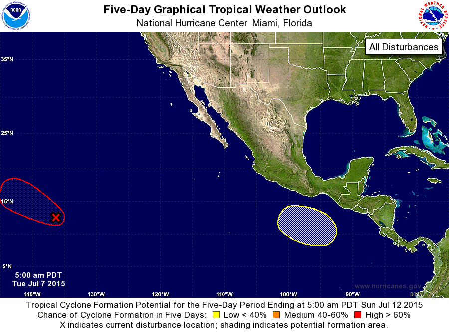
ZCZC MIATWOEP ALL
TTAA00 KNHC DDHHMM

TROPICAL WEATHER OUTLOOK
NWS NATIONAL HURRICANE CENTER MIAMI FL
500 AM PDT TUE JUL 7 2015

For the eastern North Pacific...east of 140 degrees west longitude:

1. Showers and thunderstorms associated with a large area of low
pressure located about 1300 miles east-southeast of the Big Island
of Hawaii have continued to become better organized, and satellite
wind data indicate that the surface circulation has become a little
better defined overnight.  Environmental conditions are expected to
be conducive for further development, and a tropical cyclone will
likely form later today or tonight while the system moves west-
northwestward at 15 to 20 mph.
* Formation chance through 48 hours...high...90 percent
* Formation chance through 5 days...high...90 percent

2. An area of low pressure is expected to form several hundred miles
south of southern Mexico later this week.  Some development of this
system is possible by this weekend while the low moves west-
northwestward.
* Formation chance through 48 hours...low...near 0 percent
* Formation chance through 5 days...low...20 percent

Forecaster Brennan
List of Atlantic Outlooks (May 2023 - present)
List of East Pacific Outlooks (May 2023 - present)
List of Central Pacific Outlooks (May 2023 - present)
List of Atlantic Outlooks (July 2014 - April 2023)
List of East Pacific Outlooks (July 2014 - April 2023)
List of Central Pacific Outlooks (June 2019 - April 2023)
List of Atlantic Outlooks (June 2009 - June 2014)
List of East Pacific Outlooks (June 2009 - June 2014)