


NHC Graphical Outlook Archive
|
« Earliest Available ‹ Earlier Later › Latest Available » |
GIS Shapefiles |
| Eastern North Pacific | Atlantic |
|
Tropical Weather Outlook Text
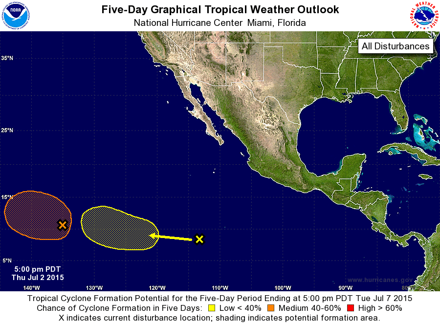
ZCZC MIATWOEP ALL
TTAA00 KNHC DDHHMM

TROPICAL WEATHER OUTLOOK
NWS NATIONAL HURRICANE CENTER MIAMI FL
500 PM PDT THU JUL 2 2015

For the eastern North Pacific...east of 140 degrees west longitude:

1. A large area of disturbed weather is located about 1500 miles
east-southeast of the Hawaiian Islands.  Environmental conditions
are forecast to become conducive for gradual development of this
system over the next several days while it moves slowly
west-northwestward.
* Formation chance through 48 hours...low...30 percent
* Formation chance through 5 days...medium...60 percent

2. An area of disorganized showers and thunderstorms located
about 1000 miles south-southwest of Cabo San Lucas Mexico is
associated with a tropical wave.  Upper-level conditions are
forecast to become conducive for some development of this system
early next week while it moves to the west-northwest at 10 to 15
mph.
* Formation chance through 48 hours...low...near 0 percent
* Formation chance through 5 days...low...30 percent

Forecaster Pasch
List of Atlantic Outlooks (May 2023 - present)
List of East Pacific Outlooks (May 2023 - present)
List of Central Pacific Outlooks (May 2023 - present)
List of Atlantic Outlooks (July 2014 - April 2023)
List of East Pacific Outlooks (July 2014 - April 2023)
List of Central Pacific Outlooks (June 2019 - April 2023)
List of Atlantic Outlooks (June 2009 - June 2014)
List of East Pacific Outlooks (June 2009 - June 2014)